


All Issues
Research highlights
Publication Information
California Agriculture 74(3):119-122. https://doi.org/10.3733/ca.2020a0013
Published online June 11, 2020
PDF | Citation | Permissions
Summary
Recent articles from the Agricultural Experiment Station campuses and UC ANR's county offices, institutes and research and extension centers.
Full text
Study challenges hypothesis that urbanization increases carbon storage in Mediterranean climate zones
When landscapes are urbanized, they can lose much of their carbon storage potential. But because urbanization often entails irrigation and tree planting, some hypothesize that urbanization can lead to increased carbon storage. Little long-term research, however, has compared carbon storage in contemporary urban areas to carbon storage in the same locations before they were urbanized.
Researchers from UC Berkeley's Department of Geography and its Department of Environmental Science, Policy and Management endeavored to quantify and map aboveground carbon storage in California's Santa Clara Valley (also known as Silicon Valley), comparing the valley's aboveground carbon storage today to storage before the widespread Euro-American modification of the 19th century. Drawing on numerous historical archival sources, the researchers developed maps of the valley's land cover circa 1850, finding that about two-thirds of land was once covered by oak savanna and oak woodland habitats. The researchers, performing calculations that involved a host of factors such as density of tree stands and diameter of trees before urbanization, estimated that the study area's carbon storage before 1850 ranged between 784,000 megagrams and 2.2 million megagrams. Contemporary carbon storage in the study area is 895,000 megagrams. These results suggest that in Silicon Valley, urbanization has resulted in changes in aboveground carbon storage ranging from a nonsignificant 14% increase in carbon storage to a significant 60% decrease over the past 160 years or so.
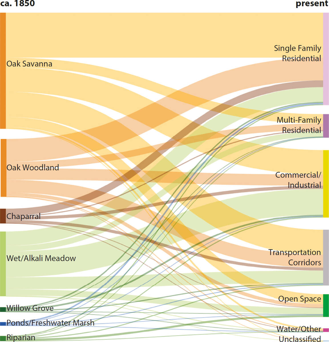
Land cover/land use transformation in Santa Clara Valley, ca. 1850 to present day (ca. 2013). The thickness of each line corresponds to the total area that has undergone each transformation.
The researchers write that their work challenges the hypothesis that aboveground carbon storage increases when Mediterranean-climate ecosystems undergo urbanization, irrigation and tree planting. Furthermore, they report that their research demonstrates the value of using historical sources from before 1900 to reconstruct the way that carbon storage and other ecosystem services have changed over long time scales.
Beller EE, Kelly M, Larsen LG. From savanna to suburb: Effects of 160 years of landscape change on carbon storage in Silicon Valley, California. Landscape Urban Plan. 2020. 195:103712- https://doi.org/10.1016/j.landurbplan.2019.103712
In Sugarloaf Creek Basin, soil water availability little changed by managed wildfire
In many forested areas in California's Sierra Nevada mountains, humans have suppressed fire since the beginning of the 20th century. Fire suppression has entailed several negative consequences, including reduced heterogeneity in the landscape and, due to high fuel loads, increasingly intense wildfires.
Managed wildfire — a policy of allowing wildfires in certain areas under certain weather conditions to burn unimpeded — is an increasingly common land management tool in California's forests. Managed wildfire, because it can reduce tree density and tree water use, can lead to increased groundwater storage, higher streamflow and greater availability of soil moisture. But little research has been conducted on the hydrologic effects of managed wildfire in watersheds such as those in the Sierra Nevada.
Researchers from the U.S. Geological Survey, the UC Berkeley Department of Environmental Science, Policy and Management and the UC Berkeley Department of Civil and Environmental Engineering studied the Sugarloaf Creek Basin, a watershed in Sequoia-Kings Canyon National Park. In this basin, fire appears to have occurred about every nine years between 1700 and 1900, with fire suppression beginning shortly before 1900. In 1968, the National Park Service adopted a policy of allowing wildfires ignited by lightning to burn; by 2016, 10 fires of 40 hectares or more had occurred within the basin. The researchers mapped the perimeters of all fires that had burned in the basin between 1952 and 2016 and — using plot measurements, remote sensing of vegetation and soil moisture measurements — characterized the response of vegetation and soil moisture to almost five decades of managed wildfire.

UC Berkeley researchers hike through a meadow in Sugarloaf Creek Basin. Under the right circumstances, allowing more fires on the landscape might help wet meadows such as this one expand in size, leading to more groundwater storage.
The researchers determined that fire in the basin over the study period had been limited to drier, mixed-conifer sites; that patches of overstory tree mortality caused by fire were limited in scope; and that fire had done little to remove trees in the middle and lower stratas. Fire had created few dense meadows; rather, fire more often had led to establishment of sparse meadow and shrub areas, whose soil moisture profiles are similar to those in nearby areas of mixed-conifer vegetation. Overall, compared to a nearby watershed that was both wetter and had burned more frequently, managed wildfire in the Sugarloaf Creek Basin had led to relatively little change in dominant vegetation and soil moisture response. The authors suggest that, during future wildfires, soil moisture increases within the basin might be encouraged by allowing greater tree mortality in areas adjacent to wetlands. Even then, they note, the hydrologic benefits of managed wildfire in a fairly dry watershed such as the Sugarloaf Creek Basin might be limited.
Stevens JT, Boisramé GFS, Rakhmatulina E, et al. Forest vegetation change and its impacts on soil water following 47 years of managed wildfire. Ecosystems 2020. https://doi.org/10.1007/s10021-020-00489-5
Fluorescent compound helps intelligent weeders in celery fields
Because field-grown vegetables at the seedling stage are highly vulnerable to weed competition, weeds must be removed early in the crop cycle to prevent yield losses. But weed control proves challenging for many growers because farm labor is often in short supply and effective vegetable herbicides sometimes aren't available. These challenges have sparked interest in intelligent weeders — autonomous machines that remove weeds while leaving crops unharmed. But intelligent weeders often struggle to differentiate weeds from vegetable crops. This challenge might be overcome through crop signaling, a technique that allows target crops to be identified rapidly and accurately.
Researchers including Wen-Hao Su and David C. Slaughter of the UC Davis Department of Biological and Agricultural Engineering, and Steven A. Fennimore of the UC Davis Department of Plant Sciences, conducted research into the ability of rhodamine B (Rh-B), a fluorescent compound with unique optical properties, to help smart machines reliably detect locations in fields of vegetable crops. The researchers applied Rh-B, in various doses and for various durations, to celery roots before transplantation to the field. The researchers assessed Rh-B transport in plants; the compound's photostability; and the compound's potential impact on seedling growth on the farm.
The researchers found that Rh-B, when absorbed through celery roots, moved throughout the plant in 24 hours. Higher doses of Rh-B led to more absorption, but also injured plants. The researchers determined that treating celery roots with a solution containing 60 parts per million of Rh-B was safe for plants and led to good photostability in seedlings for about five weeks after transplanting. Such a dose allowed a machine vision system to rapidly identify celery plants at the early growth stage and therefore to differentiate between crops and weeds.
Su W-H, Slaughter DC, Fennimore SA. Non-destructive evaluation of photostability of crop signaling compounds and dose effects on celery vigor for precision plant identification using computer vision. Comput Electron Agr. 2020. 168:105155- https://doi.org/10.1016/j.compag.2019.105155
Camera traps used for estimating population demographics of deer
Populations of black-tailed deer have declined in the western United States over the last several decades. Researchers from UC Berkeley and UC Davis conducted research to test whether camera traps can be used to quantify population characteristics of black-tailed deer. The researchers, using images of naturally occurring physical characteristics of deer — including antler patterns for males and ear notches for females — developed a model that allowed them to estimate deer abundance, sex ratios, size of individuals' home ranges and more.
The researchers placed 13 cameras at water sources on a private ranch in California. They placed bait in front of each camera once a month. Between May 2012 and January 2013, they recorded 9,000 visits by 50 individual deer. They estimated deer populations in the area at 7.7 animals per square kilometer in the summer and 8.6 in the fall; a sex ratio of 12.5 males to 100 females; and a ratio of 47 fawns to 100 adult females. According to the researchers, their work demonstrates that commonly deployed camera traps can help to quantify population characteristics and monitor populations — and can aid in decision making about harvesting and habitat management.
Macaulay LT, Sollmann R, Barrett RH. Estimating deer populations using camera traps and natural marks. J Wildlife Manage. 2019. 84(2):301-10. https://doi.org/10.1002/jwmg.21803
Land managers weigh in on weed invasion
Working rangelands and natural areas, which account for about 64% of land in the United States, provide valuable environmental goods and services. Weed invasion in such areas poses significant ecological and economic threats, including reduced livestock forage quality, depleted soil and water resources and reduced plant diversity. Though invasive weed control has been the subject of considerable research, research has largely neglected to tap the very extensive weed-management experience of restoration practitioners and land managers.
To redress this gap, researchers from UC Cooperative Extension (UCCE), the UC Davis Department of Plant Sciences and the University of Arizona, with support from the California Department of Pesticide Regulation, surveyed more than 250 rangeland managers and restoration practitioners in California. The practitioners were asked to identify their land management goals; to rate the effectiveness, vis-à-vis weeds, of management practices such as prescribed fire, grazing, herbicide use and seeding; and to identify barriers to implementing specific practices.

In a survey of California rangeland managers and restoration practitioners, medusahead (along with yellow starthistle) was identified as the most problematic invasive plant.
Practitioners identified 196 problematic plants. The two most often mentioned were yellow starthistle and medusahead. The highest-rated management practice was herbicide use — but respondents identified several barriers to using herbicides, including cost and public perception. Many respondents expressed interest in grazing as a management tool for invasive and woody species, but 19% of those who had tried it did not believe it was effective. The researchers found that, across management practices, issues such as permitting and livestock water availability represented barriers to implementation. The researchers suggest that, because the land management goals and issues of concern identified by respondents were similar across the state, targeted research and outreach efforts involving both scientists and land managers can provide benefits across California's rangelands and natural areas.
Schohr TK, Gornish ES, Woodmansee G, et al. Practitioner insights into weed management on California's rangelands and natural areas. Environ Manage. 2019. 65:212-9. https://doi.org/10.1007/s00267-019-01238-8
Enhancements to promote bee pollination of crops may help bees more than crops
Efforts to support ecosystem services — that is, the ecosystem functions on which human well-being relies — are often portrayed as compatible with efforts to conserve biodiversity. But if just a few species are adequate for local delivery of ecosystem services, support for those services may benefit only a small set of common species. For example, some bees provide ecosystem services in the form of crop pollination — but if agricultural conservation efforts benefit only the bee species that pollinate crops, these efforts may fail to protect bee diversity broadly.
A national team including four researchers from the UC Davis Department of Nematology and Entomology conducted research over two years at farms in California, Michigan and Oregon to determine whether abundance of wild bees is increased by enhancing the richness and abundance of flowers in habitat adjacent to crops. At each study site, the researchers seeded some field edges with flowering forbs and left other edges unenhanced. Across the four regions, the researchers collected nearly 4,200 wild bee specimens. They found that bee communities in enhanced field edges, compared to those in control edges, were more abundant, taxonomically and functionally diverse and compositionally different. At the same time, they found that enhancements did not increase the abundance or diversity of bees visiting crops — that is, enhancement did not change the supply of pollination services. They conclude that attempts to promote crop pollination may deliver multiple biodiversity benefits but may not benefit crop pollinators, at least over the duration considered in this study (previous work in Michigan has shown that the benefits to crops from enhancing habitats can take years to accrue). It is important to safeguard biodiversity and ecosystem services. More research will show how best to comanage pollinators and crop pollination.
Nicholson CC, Ward KL, Williams NM, et al. Mismatched outcomes for biodiversity and ecosystem services: testing the responses of crop pollinators and wild bee biodiversity to habitat enhancement. Ecol Lett. 2020. 23(2):326-35. https://doi.org/10.1111/ele.13435
E. coli survival on romaine depends in part on time of inoculation
Eating plant-based foods contaminated with pathogenic strains of E. coli can lead to gastroenteritis; leafy lettuce in particular has been implicated in outbreaks of gastroenteritis around the world. Some outbreaks in the United States have been traced to California and Arizona, where most of the nation's leafy greens are grown.
Contaminated water is often the route by which plants are exposed to E. coli. Knowing the rates at which pathogens such as E. coli die off, after they have contaminated plants, is useful for making microbial risk assessments and for developing strategies to reduce the risk posed by pathogens in agricultural water.
Low solar radiation, high humidity and moisture on leaves are thought favorable for the persistence of E. coli on plant surfaces. At night, in California's Salinas Valley, humidity levels rise and water condenses on leaf surfaces. In the daytime, factors such as higher temperatures and lower humidity cause leaf surfaces to dry. Researchers from the UC Davis Department of Food Science and Technology, the Western Center for Food Safety at UC Davis and UCCE in Monterey County conducted experiments over three years to determine the effect that time of inoculation, age of plants and inoculum levels exert on E. coli survival.
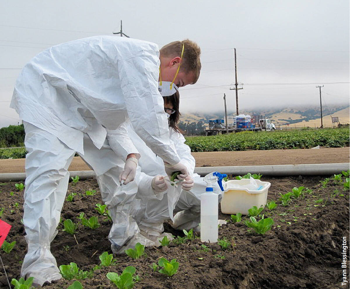
Researchers incoluate four-week-old romaine lettuce plants with E. coli, a pathogen associated with outbreaks of gastroenteritis. E. coli survival can be affected by time of inoculation, age of plants and inoculum levels.
The researchers inoculated romaine lettuce plants with the attenuated pathogen (a form that cannot cause illness). Plants were either four or six weeks old; inoculation occurred either at night or in the morning; and inoculation levels were either low or high. They found that E. coli populations declined faster when inoculation occurred in the morning than at night — but that after two days and seven days, similar numbers of E. coli cells could be retrieved from plants. After seven days, E. coli cell numbers were significantly higher on six-week-old than on four-week-old plants — indeed, the researchers found that the age of the plant influenced pathogen survivability more than did time of inoculation. They further report that, even if low levels of pathogen are introduced to plants, the risk of pathogen survivability is greater when contamination occurs under humid conditions, near harvest or at night.
Moyne A-L, Blessington T, Williams TR, et al. Conditions at the time of inoculation influence survival of attenuated Escherichia coli O157:H7 on field-inoculated lettuce. Food Microbiol. 2020. 85:103274- https://doi.org/10.1016/j.fm.2019.103274
Tool developed, suitable for citizen scientists, to assess drinking water access in schools
Under the provisions of the Healthy, Hunger-Free Kids Act, schools that serve meals must provide students free access to drinking water in cafeterias at mealtimes, in part because intake of sweetened beverages can cause obesity and tooth decay. A high proportion of schools reports compliance with the law's provisions, but direct observation by researchers has indicated that only 48% to 58% of schools comply. Furthermore, the presence of drinking water might not result in greater water consumption if the water itself is unappealing, the flow of water is poor or drinking vessels are not provided.
The gold standard for assessing drinking water availability in schools is direct observational auditing by researchers, but audits of this kind are resource-intensive. Researchers including Lorrene Ritchie, the director of UC ANR's Nutrition Policy Institute and a UCCE specialist, and Christina Hecht, a senior policy advisor at the Nutrition Policy Institute, undertook to develop a more cost-effective photography-based tool, based on the Harvard Water Audit tool and usable by citizen scientists, that could provide accurate information about water access in schools. Their research also entailed efforts to assess the validity and feasibility of the tool.
Researchers using the tool photographed water sources at schools, including features that researchers hypothesized to be associated with students' intake of water. These features included locations of water sources, evidence of wear on drinking water sources, cleanliness and water flow. Researchers also performed observational audits of drinking water conditions at the same schools. The tool was reviewed by experts, pilot-tested, adapted as necessary and ultimately used at 30 schools in the San Francisco Bay Area. The photographs were then coded, and the information derived from them was compared to information gathered through observational audits. The results of the two methods were found to agree very well on almost all characteristics measured (though agreement was less strong for cleanliness of and wear on water sources). According to the researchers, the evidence suggests that the photo-evidence tool provides a valid, more cost-effective assessment of drinking water access in schools, and holds excellent promise for use by citizen scientists.
Patel AI, Podrabsky M, Hecht AA, et al. Development and validation of a photo-evidence tool to examine characteristics of effective drinking water access in schools. J School Health. 2020. 90(4):271-7. https://doi.org/10.1111/josh.12873
Research highlights

