


All Issues
Landscape changes in Nevada County reflect social and ecological transitions
Publication Information
California Agriculture 57(4):115-121. https://doi.org/10.3733/ca.v057n04p115
Published October 01, 2003
PDF | Citation | Permissions
Abstract
Large-scale migration of urban people seeking a better quality of life in rural places has generated considerable concern about “rural sprawl.” In a multimethod, fine-scale, longitudinal study of land ownership and use in Nevada County, we found that this quintessential “exurban” community reveals a complex story of interacting social and ecological change with some reasons for concern, but also optimism. Land-use data from 1957 to 2001 shows dramatic fragmentation of the county's landscape as a result of increased residential use. The full scale of this transition is not visible because many parcels that are already zoned for further subdivision and residential use remain undeveloped. The related ecological changes have been mixed so far, with tree cover and riparian areas recovering from historic mining, ranching and timber harvesting. These changes are not incidental: many residential owners expressed a strong conservation ethic. However, ecologically harmful effects of increased residential use are present as well. In surveys and interviews, rural-residential owners revealed conflicting feelings about their changing landscape: most are concerned about preserving their quality of life and preventing the ecological impacts of further growth, but also do not want additional government regulations. Research on a fine scale into the cultural basis of ecologically beneficial and harmful rural-residential land-use practices can assist policymakers in crafting innovative and effective growth-management institutions.
Full text
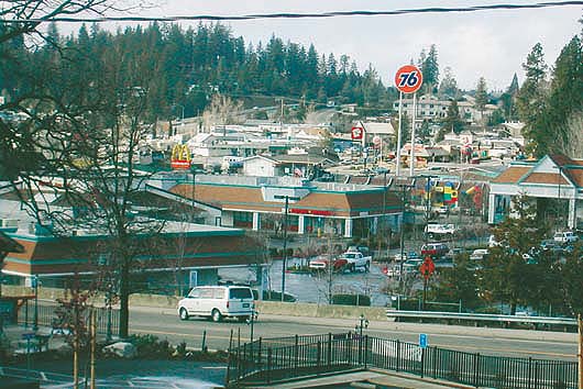
About an hour's drive east of Sacramento in the Sierra Nevada, Nevada County typifies expansion of the “exurbs,” which have experienced dramatic population growth in recent years. Grass Valley (Brunswick basin) is a small but growing city in the primarily rural, agricultural and residential county.
Nevada County landscape
During the 1990s some of the nation's fastest-growing counties were “exurbs,” encompassing small towns that receive migrants from expanding metropolitan areas; the populations of some nearly tripled during the 1990s alone and continued to increase more than 10% annually (Pollard 2003; Johnson 1999). The ecological and social effects of the resulting growth or “sprawl” rapidly emerged as the focus of major public policy debates. This study addresses the effects of massive population growth in Nevada County, Calif., during the second half of the 20th century.
It differs from other studies on the effects of exurban growth in two significant ways. First, the ecological data was collected on private land, which not only is underrepresented in studies of conservation and biodiversity, but also tends to have greater habitat amenities than public land (Hilty and Merenlender 2003; Hansen and Rotella 2002). Second, we analyzed the interrelations between cultural attitudes, land use and landscape change in exurban landscapes (regions outside a city and usually beyond its suburbs, typically inhabited by well-to-do residential households [Spectorsky 1955]). Much exurban migration has been motivated specifically by a desire to live in a relatively natural setting (Jones et al. 2003). Nonetheless, until recently (Nelson 2002; Walker and Fortmann 2003) little attention was paid to the role that cultural views play in shaping environmental change and management in rural-residential or exurban landscapes (Nassauer 1995).
The story of change in Nevada County's landscape illustrates the interaction of ecological, social and cultural processes. We have framed it in terms of three transitions: the rural-residential transition; an invisible transition as spaces that appear open today have been subdivided and zoned for future development; and visible transitions on the land. It is not a story encompassed by the metaphor of a coin with two sides, one ecological and the other social/cultural. Rather, it resembles a Mobius strip with ecology and culture intertwined on its only side. One cannot be understood without the other.
Sierra Gold Country
Located northwest of Lake Tahoe in the oak woodlands and conifer forests of the Sierra Nevada, Nevada County is in the heart of California's historic Gold Country and includes the small cities of Grass Valley, Nevada City and Truckee. Since the Gold Rush of 1849, the region has experienced dramatic transformations of its society and landscape (SNEP 1996). Following the Gold Rush, open-range cattle grazing, orchards, timber production and deep, hard-rock gold mining became the economic mainstays. By the mid-1950s, however, the last major commercial mines closed and the traditional natural resource-based economy went into steady decline. By 1998, employment in agriculture, forestry and mining (together) in Nevada County dwindled to about 2% of local jobs (SEDD 2001). Currently the county's economy is based primarily on income from non-wage-related sources such as dividends and pensions; its salary base is mostly local service-sector employment and businesses (SEDD 2001).
By the late 1960s a “second Gold Rush” Duane 1996) arrived, in the form of land speculation and development for waves of residential migrants moving to the county in search of investments in cheap land and a better quality of life. Located only an hour drive from Sacramento and a 2.5-hour drive to the San Francisco Bay Area, Nevada County's open spaces and scenic qualities became a magnet for these exurban migrants. Between 1965 and 2001, the county's population nearly quadrupled, from 25,100 to 94,361, almost exclusively through in-migration (Berliner 1970; U.S. Census Bureau 2003). This in-migration fundamentally changed the county's economy, culture and landscape.
Nevada County is an ideal place to study the effects of exurban in-migration that is transforming many rural areas. The Sierra Nevada is a harbinger of changes occurring throughout rural America, and Nevada County has been among the Sierra region's fast-growing counties.
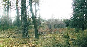
Over the past half-century, the authors found that many of Nevada County's private landowners have allowed their property to be revegetated and reforested following decades of clearing for logging, mining and ranching.
Transects and interviews
In 1957, Teeguarden et al. (1960) drew north-south sampling transects at 2- and 3-mile intervals on vegetation maps of Nevada, Placer and El Dorado counties and recorded land ownership and use among owners whose parcels intersected the transects. We conducted a restudy of the Nevada County transects, documenting changes in ownership, use and land cover between 1957 and the present. Mail surveys on the histories of parcel ownership, use and management as well as attitudes about the environment and government regulation were completed by the current owners of 358 parcels that lie on the original 1957 transects.
We also conducted 26 follow-up interviews with survey participants, as well as 93 interviews with landowners who did not participate in the survey and 49 interviews with county officials, activists and long-time residents. We compared ownership and land-use data with Teeguarden's 1957 baseline data and tracked changes in land cover on the sample parcels at two spatial and temporal scales. Vegetation changes on 140 parcels were tracked for each decade using fine-scale aerial photographs covering 1952 to 2000. Coarse-scale vegetation changes were tracked on 549 parcels at two time periods, 1948 through 1950 and 1996 through 2000, using vegetation stand maps prepared by the California Department of Fire and Forest Protection (CDF) and the U.S. Forest Service (USFS). The base period of 1948 to 1950 consisted of USFS-CDF timber stand maps interpreted from aerial photography (USDA 1949) and the 2000 CDF CALVEG map for Nevada County interpreted from Thematic Mapper satellite data (CDF 2000).
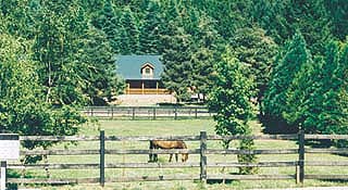
The county's rural landscape is at risk, with 40% of privately owned parcels slated for development. A golf course, 2,000 homes, business park and shopping center are proposed for this 760-acre Northstar property.
Rural-residential transition
Most rural landowners in Nevada County come from someplace else. Just over 3% of 736 adults residing in the households that returned our mail survey were born in Nevada County, and 85% first acquired land in the county since 1968. In-migration brought dramatic changes in land use. In 1957, private, rural, land use in Nevada County was roughly evenly divided among agriculture, timber and residential/recreational use — with small amounts of mining and other commercial uses. By 2001, private land under rural-residential and recreational use had increased from 30% to 70%. Mining and other commercial uses dropped to 2% and timber from 31% to 18%. Agricultural land (used for farming as a full-or nearly full-time occupation) decreased from 33% to 10%. We defined land used for part-time, small-scale agricultural activities (hobby farming) as primarily residential. The California Department of Conservation (2000) indicates that if very small-scale farming is included in the definition, agricultural land has increased slightly in recent years, although not reversing the longer-term downward trend.
The increase in rural-residential land use is associated with a decrease in the size of landholdings (the total acres in all parcels held by a single owner). The median size of landholdings in Nevada County decreased from 550 acres in 1957 to 9 acres in 2001, reflecting a shift from large ranches and timber operations to single-family residential units on parcels typically ranging from 3 acres to 15, 20 or occasionally 40 acres or more. The 1957 landscape of a few large parcels has been almost completely replaced countywide by a fragmented landscape of many small parcels.
Rural-residential landowners use their land in a variety of ways that challenge a simplistic understanding of a rural-residential landscape as synonymous with suburban sprawl. In Nevada County, many primarily residential owners engage in small-scale farming, ranching and/or timber production. Of the mail survey landowners, 83% primarily used their land for residential purposes, 10% for commercial agriculture, ranching or timber production, and 4% for recreation. A few said they keep the land simply to preserve open spaces. Thirty-five percent of primarily residential landowners (typically with larger parcels) practice small-scale farming, ranching, timber production and other small-scale commercial uses such as home-based businesses and crafts workshops. Therefore, some land that has been converted from large ranches and timber operations to residential use retains a degree of rural or agricultural use.
The invisible transition
The view seen by residents and visitors to Nevada County does not reveal the full extent of the transition to an increasingly fragmented landscape. Nothing in the landscape reveals, for example, the precarious financial position of most remaining large farms and ranches, which give Nevada County a rural feel. In our research, ranch owners expressed doubts that their children or grandchildren would be able to continue to farm the land and keep these remaining open spaces undivided. More important, much of the county's open space is already zoned and intended for future residential development. Much of the open space in Nevada County today is composed of parcels zoned for agricultural or rural-agricultural uses that, under current General Plan designations (most recently revised in 1995) and zoning rules (implemented in 1997), may be subdivided into 3-acre parcels with a single dwelling unit. Other undeveloped parcels were subdivided under earlier zoning rules that were implemented during the 1960s and 1970s at even higher densities, and some planned-unit developments may allow 15 units or more per acre. More restrictive zoning policies, driven by fears among many in-migrants of an eroding quality of life due to explosive growth, began in earnest only in the 1980s, but by that time much of the landscape had already been zoned at higher densities. Thus, in their current undeveloped condition these areas give a misleading sense of open space that masks the large amount of land already planned, zoned and intended for future development.
Public records from the Nevada County Tax Assessor's office for 2001 indicate that 15,064 (40%) of the county's private rural parcels can be developed for residential or commercial uses according to existing zoning designations. More than 3.5 times as much private rural land (281,689 acres) remains available for future development as all the private rural land already developed in the county (76,145 acres)(fig. 1). The “checkerboard” pattern in the county's central and eastern areas was created when 19th-century surveyors created a grid of 1-mile-square sections for federal land grants; alternating sections were retained as public land (now the Tahoe National Forest). Our criteria for identifying parcels that remain available for development included: a) privately owned; b) current zoning rules allowing development or subdivision; and c) current improvement value less than $20,000, indicating that no residential unit is present, making the parcel eligible for further development. Figure 1 includes parcels designated as a Timber Preserve Zone and current timber-producing parcels that can be developed under existing zoning rules.
Nevada County's landscape is deceptive in its feeling of openness. Viewed through the lens of parcel maps and zoning rules, we see a landscape that has already been carved into many parcels owned largely by those who are waiting for the right time to build. In our research, both absentee and resident owners of undeveloped parcels almost universally indicated that they intend to develop these properties for retirement or plan to sell to others for development. The population implications of this potential development are dramatic. The county's estimated 2001 population is 94,361 (US Census 2003). By multiplying the number of parcels available for residential development by the number of dwelling units allowed by zoning rules on each parcel, and multiplying again by the average number of persons per dwelling unit (2.47 per unit in Nevada County, according to the U.S. Census), we find that the “build-out” population that can be reached under current zoning rules is 233,522 people — 2.5 times the current population. The visible landscape conceals a future that has already to a large extent been determined, unless policies are put in place that further limit development.
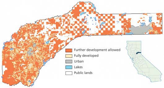
Fig. 1. Potential development in rural Nevada County. About 76,145 acres are currently developed; additional development is allowed on 281,689 acres. Source: 2001 County Assessor's parcel data.
Visible transitions on the land
Data from the Nevada County Tax Assessor's office for 2001 shows that while suburban-style parcels of 1 acre or less account for 31% of all private rural parcels, they represent only 1.5% of the total private rural acreage (0.9% of the total area). As such, highly visible suburban-style developments have relatively little spatial impact on the landscape. Much more of the rural landscape is dominated by low-density residential development on parcels typically ranging from 5 to 40 acres. Most research on the Sierra landscape has been conducted using satellite imagery at a geographic scale of analysis of 40 acres or more (considerably larger than the majority of parcels), which is unable to reveal complex changes in areas composed of a mosaic of residential uses. Rural-residential development in areas formerly dominated by ranching and timber production is often portrayed as an unmitigated environmental detriment (Maestas et al. 2001; Hansen et al. 2002). Our preliminary analysis suggests that the overall impact of the residential transition is mixed and should not invariably be considered ecologically harmful.
The most notable vegetation transition found on our sample parcels was increased canopy closure across all forest types, including conifer, hardwood and mixed hardwood-conifer forests. This pattern was consistent across almost all sample parcels, and is strongly consistent with findings of increasing tree cover in neighboring Placer and El Dorado counties (Saah 2001; Wacker 2002). Most of Nevada County's historic forest cover — conifer, mixed conifer-hardwood forests and oak woodlands — was logged or cut during the Gold Rush. Cut-over land was later heavily ranched, leaving a sparsely vegetated landscape by the 1950s. The greatest transition observed from the early 1950s to late 1990s (using our two-time-period analysis of 549 parcels) was from small woody growth (the CDF timber stand maps did not distinguish between shrubs and small hardwoods) to dense hardwood forest. In the early 1950s, this shrub-statured woody growth was the most common vegetation type on all parcels in our study area. The second greatest transition was from sparse conifer forest with shrub-statured vegetation to mixed hardwood-conifer forest, also reflecting the change from small to mature hardwoods. This forest regrowth appears to have been accelerated by many residential owners choosing for cultural reasons not to harvest timber, graze cattle or clear trees.
Exceptions to the pattern of forest regeneration are: areas of recent wildfires; portions of land logged by residential owners; and areas immediately surrounding residential structures, often cleared of conifers for fire prevention. With the expansion of conifer and hardwood forests, the diversity of other vegetation types decreases as forest encroaches or replaces annual grassland and short-statured woody vegetation. In Nevada County, we observed the expansion of improved road networks that fragment the landscape and a simultaneous disappearance of older networks of logging and ranching roads. While new residential buildings are going up, many previous agricultural structures have also been removed. Moreover, the type of land use associated with the presence of human-made structures is generally more ecologically important than the structures themselves. The types of land use associated with residential homes today — such as simply leaving the land “natural” for aesthetic or recreational purposes, or small-scale recreational farming (what long-time local farmers call “hobby farming”) — are very different from those associated with the agricultural structures and farmhouses that dominated in the 1950s. The appearance of new houses on large, rural-residential parcels may be less significant than the fact that these houses signal a new regime of land use.
The rural-residential transition is having significant impacts on vegetation and forest density in many areas of Nevada County. Figure 2 shows a typical 40-acre parcel near Nevada City occupied by one single-family residence, which has been used exclusively for residential purposes for more than 25 years. The black-and-white maps illustrate a dramatic increase in overall tree canopy between 1952 and 2000 (fig. 2A). The color maps illustrate a more subtle transition, with an overall trend from a landscape of mixed hardwoods and conifer patches with moderate cover of shrubs or grass to a landscape increasingly dominated by conifer forest (fig. 2B).
It is widely accepted that the presence of more houses is associated with increased disturbance of wildlife (due to fence construction, and harassment and predation by domestic cats and dogs) and decreased biodiversity (Hansen et al. 2002; Hansen and Rotella 2002). These findings do not differentiate among different land-use practices, especially on large parcels with a greater diversity of land uses. Our study shows that there are many relatively large (10 to 60 acres) residential parcels in Nevada County where the impact of domestic activities may be relatively minor and whose owners practice active management of forests and vegetation to reduce fire hazards. Particularly on larger parcels, the ecological impacts of residential use in comparison to uses such as ranching and logging appear less clear than the literature portraying residential development as ecologically harmful suggests. For example, our study suggests that many rural-residential owners in Nevada County allow riparian vegetation to regrow, resulting in significantly improved conditions compared to ranching and agricultural use, in which cattle and erosion, and pesticide and fertilizer runoff often harm stream conditions.
What rural landowners want…
Nevada County's growth is primarily driven by quality-of-life values rather than economic opportunities. For 71% of mail survey landowners, the most important reasons for coming to Nevada County were landscape quality (scenery, environmental qualities and open spaces — 54%); recreational values (8%); and opportunities for farming and other resource uses (9%). With inclusion of the 24% who wanted to “get out of the city” (a push factor closely intertwined with the pull of the rural landscape), 95% of respondents considered the quality of the landscape, directly or indirectly, the major attraction. Other important attractions included “sense of community” (6%) and a desire to be near relatives or friends who live in the county (3%). Only 6% cited a job as their most important reason. (Many in-migrants are retired or do not work: 32.9% of Nevada County households receive Social Security income, and 40.8% of adults are not in the labor force [US Census 2003]).
While Nevada County land-use debates have been framed as the agricultural and timber economy versus environmentalists, 78% of landowners in our mail survey saw both as important to the county's future. They also tended to agree that a common enemy — runaway growth — threatens these desirable landscape features. When 93 rural landowners were asked in interviews whether they favor more growth, controlled growth, no growth or had no opinion, 68% favored controlled growth, which most respondents interpreted as strict zoning and minimum parcel sizes.
Rural landowners tended to support agriculture because it provides open spaces and scenic qualities, helps to preserve a sense of rural community and a “slower pace of life,” and is an important part of the county's history. Some respondents viewed agriculture as generally compatible with responsible environmental management. Others expressed concerns, such as the effects of grazing and fertilizer runoff. Many stated that they believe there is a future for timber production in Nevada County, even while expressing concerns about specific timber practices, especially clear-cutting. Even those expressing strongest support for the natural resource-based economy had serious misgivings about the environmental effects of mining.
Respondents in the mail survey and personal interviews often observed that growth is inevitable but emphasized that they would hate for the county to end up looking like the urban and suburban places they left behind. Many said they accept growth because they feel it is unfair to close the door behind them, but often feel strongly that growth should be regulated. The reasons for controlling growth were diverse. Some saw advantages in growth such as easier access to shopping and lower prices, and believed that it would enhance their property values. These same landowners tended to express deep reservations about the capacity of the county to handle growth, especially impacts on local infrastructure such as excessive traffic on rural highways and overburdened water supplies. Others perceived growth as inevitable, but wanted to protect the county's wild and rural feel.
Many cited personal experiences witnessing the overdevelopment of their old hometowns in what are now major urban areas. Fourteen percent in the mail survey and interviews declared that they were in favor of stopping all growth in the county. One declared, for example, that the county is being destroyed for the “almighty buck,” and another said she “doesn't care what happens to land values … the county needs open spaces, not more tickytacky.”
Twelve percent of the mail survey said that growth is good for jobs and generally brings conveniences to the county. Those who saw a positive side to growth were often among the most concerned about possible infringements on property rights under policies of growth control. Supporters of growth also included long-time residents who observed that the county was boring and kids had nothing to do before the county grew. In sum, the great majority of rural landowners who participated in our study appeared to recognize that growth will happen and wanted its effects to be controlled. Minorities of roughly equal size either advocated or opposed growth in any form. And there were mixed feelings. One respondent observed, “We bought the land [in the 1980s] because we liked the wildness and the remoteness. However … every development that brings civilization and population closer also raises the value [of our property], so we consider the investment factor but do not intend to sell — so there goes that argument! Clear as mud? That' s how we feel, too.”
… and what they will do to get it
While 68% of our interview respondents reported that they want to see growth controlled, feelings about land-use controls in general tended to be highly negative. Fifty-nine percent disagreed with the statement that the county needs strong controls on land use. Only 34% agreed with this statement.
Consistent with the generally negative view of government controls, 81% of mail survey landowners agreed that “Nevada County needs strong protection of private property rights.” Only 11% disagreed. These negative views of government control and strong support for property rights are consistent with the strongly conservative bent of the county. Most respondents, when asked in the abstract where they stand on these issues, tended to take conservative positions. However, when respondents were asked more specific questions pertaining to particular types of government controls or specific issues relating to property rights, their views took a more conservationist position. Seventy-one percent agreed that the county needs strong environmental protection, while 23% disagreed. Notably, 62% who strongly agreed that Nevada County needs strong protection of property rights also agreed that it needs strong environmental protections. Similarly, 46% who strongly disagreed with the need for strong government control of land use on private property agreed that Nevada County needs strong environmental protection.
While a few argued that environmental protection can be achieved without government involvement, more recognized the contradiction in their opinions. Many respondents who strongly supported property rights and rejected government controls in the abstract nevertheless acknowledged strong support for specific government interventions to protect the landscape. Support tended to be very strong for minimum parcel sizes and zoning restrictions even among otherwise steadfast conservatives. When it comes to protecting the landscape, conservatives in Nevada County often seemed to be conservationists. For example, in the November 2002 county supervisor elections in the Third District, which is 43% Republican and 35% Democrat, a slow-growth candidate depicted by opponents as an environmental extremist lost by a razor-thin 19 votes. More broadly, rural landowners appeared to agree on the importance of protecting environmental and rural qualities. This view transcends party affiliations or ideologies and has become an enduring feature of the cultural and political landscape of the county.
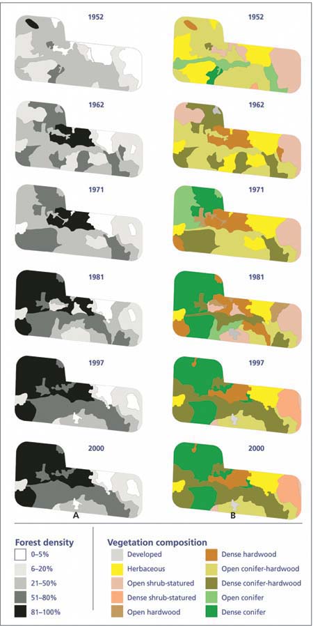
Fig. 2. Changes in (A) forest density and (B) vegetation composition from 1952 to 2000, on a 40-acre parcel in Nevada County, Calif.
Under current zoning, Nevada County's population could more than double as private lands are sold for development. About two-thirds of those surveyed wanted to see growth controlled, but almost as many did not support government controls on private land use.
Land-use realities, contradictions
Our data revealed contradictory tensions in Nevada County. Based on our ecological data, we could argue that certain types of residential development and land use may be less harmful to the landscape than extractive uses. Others could also argue that low-density residential development is inherently inefficient and wasteful, resulting in fragmentation of the landscape, more public-sector costs and creation of sprawl by spreading population over a wider area. Similarly, there are tensions between the strong desire and willingness to protect the environment and ideological opposition to the most common ways of doing so.
Our research suggests that certain questions about the interrelationship between social and environmental change in exurban landscapes need to be re-examined at a finer scale. It also suggests that in some exurban landscapes the questions that have drawn the greatest research interest may no longer be relevant. In places like Nevada County, the time for the “cows versus condos” debate (Knight et al. 1995) is past. The condos won. The questions that need to be asked now concern how to make this rural-residential transition work better — and these are questions that require fine-scale, integrated, social and ecological research.
Property owners, planners and government regulators must recognize that ecological changes in the landscape are not the coincidental outcomes of solely natural processes. Rather, they reflect cultures and images of landscape brought by in-migrants who literally recreated the landscape through their own practices and influence on land-use policies, in their image of what was rural and natural (that is, forested).
In Nevada County, creating and sustaining healthy ecosystems requires the ability to base policy on cultural and ecological interconnections. By studying at a fine-scale which rural-residential practices are harmful and beneficial to a healthy and livable landscape, the basis for encouraging or discouraging particular land practices can be developed. By understanding the cultural basis of rural-residential land-use practices, policies can reflect the desired images of landscapes. And finally, by understanding the cultural bases of responses to policy, innovative policy institutions can be crafted that are culturally acceptable and ecologically effective.
Landscape changes in Nevada County reflect social and ecological transitions

