


All Issues
Impact of firewood harvesting on hardwood rangelands varies with region
Publication Information
California Agriculture 50(2):7-12. https://doi.org/10.3733/ca.v050n02p7
Published March 01, 1996
Abstract
Aerial monitoring of hardwood rangelands over a 4-year period revealed that almost 70,000 cords of firewood ware harvested annually on approximately 6,000 acres. This represents less than 0.1% of the total hardwood rangeland in the state. Over 50% of the firewood volume harvested during these 4 years was in Shasta and Tehama counties, although these two counties represent less than 10% of the hardwood rangeland acreage in the state. In Tehama County, tree growth outpaced harvest, but in Shasta County, harvest exceeded growth by 30%. Both counties' governments adopted resolutions calling for a retention of 30% crown cover following firewood harvest. This retention level attempts to balance the needs for profitable livestock management with wildlife habitat needs.
Full text
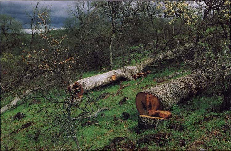
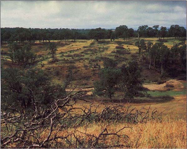
Firewood harvesting on hardwood rangelands was observed on 6,000 acres annually between 1988 and 1992.
California's hardwood rangelands cover an estimated 7.4 million acres in the state. This area is characterized by an overstory canopy cover of at least 10% hardwood tree species, predominantly in the oak genus (Quercus spp.), with an understory of annual grasses and occasional native perennial grasses. Since European settlement of California, hardwood rangelands have been managed primarily for livestock production. These areas recently have taken on new importance as people realize hardwood rangelands provide one of the richest wildlife habitats in the state, with 331 vertebrate species relying at least partly on oak woodlands for habitat. Other public values provided by these areas include water quantity and quality, outdoor recreation and aesthetics. California's hardwood rangelands are unique in the West in that 80% of this acreage is privately owned.
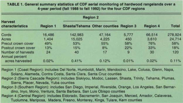
TABLE 1. General summary statistics of CDF aerial monitoring of hardwood rangelands over a 4-year period (fall 1988 to fall 1992) for the four CDF regions
Because of the significant ecological values supplied by hardwood range-lands, sustainability of these oak-dominated habitats has great public importance. In 1986, UC, along with the California Department of Forestry and Fire Protection, the California Department of Fish and Game, and the State Board of Forestry, initiated a program of research, education and monitoring to conserve the state's hardwood rangelands: the Integrated Hardwood Range Management Program (IHRMP).
Since 1945, an estimated 1 million acres of hardwood rangelands have been converted to other land uses. Beginning in the mid-1970s, firewood harvest on hardwood rangelands — often coupled with range improvement practices — increased as markets for firewood expanded. However, little information existed on the amount of firewood being harvested, the regional distribution of harvest or its impact on resource values.
This paper summarizes the results of several assessments of firewood harvest on hardwood rangelands, and shows how this information is being used to develop policies designed to sustain hardwood rangeland values.
Statewide firewood harvest trends
The California Department of Forestry and Fire Protection (CDF) was given responsibility by the IHRMP for monitoring the status of hardwood rangelands in the state. In an initial assessment of the statewide impact of firewood harvest, CDF conducted aerial monitoring from fall 1988 through fall 1992, using fixed wing aircraft flyovers and local agency observers to examine firewood harvest. All the principal hardwood rangeland regions in the state were surveyed three times over the 4-year period. This aerial survey was designed to show general trends in the acreage of harvest and level of canopy reduction. Local CDF personnel flew systematic grids over regions under their jurisdiction, attempting to locate all major firewood harvesting operations that had taken place in the past year or since the previous flyover. Each harvest location was recorded spatially and on the CDF Hardwood Rangeland Geographic Information System (GIS). Aerial observers estimated precut canopy cover of harvested areas by comparing the adjacent uncut areas, as well as postcut canopy cover and acreage of harvest.
Using these canopy cover estimates, the volume per acre harvested also could be estimated for each location using the general relationship between crown cover and volume (see California Agriculture July-Aug. 1988). The total volume harvested at each location was estimated by multiplying the calculated volume per acre by the acreage of the operation. Table 1 shows the general 4-year harvest levels derived from these CDF aerial observations. Almost 280,000 cords were harvested on nearly 25,000 acres. These figures represent a conservative estimate: the aerial surveys may have omitted small or very light, partial harvests since they would have been difficult to detect from the air. However, local observers felt that virtually all major commercial harvest operations during this period were included.
More than half of the firewood volume harvested during these 4 years was in Shasta and Tehama counties, although these two counties represent less than 10% of the hardwood rangeland acreage in the state. Over the 4 years, statewide annual firewood harvest averaged only 0.1% of all hardwood rangeland acreage in the state. Despite this low percentage, however, there is still concern that many of the harvest sites exceed the minimum canopy retention threshold of 25% cover in the IHRMP's Preliminary Guidelines for Managing Hardwood Rangelands, and the Department of Fish and Game's 40% canopy retention standards. In fact, 96 of the 120 firewood harvest sites detected in the aerial survey fell below these recommended canopy retention minimums. This may create locally significant impacts in some watersheds and will be investigated in future landscape analysis projects.
Growth and harvest
To assess the sustainability of harvesting a much higher percentage of hardwood rangeland, we compared total oak tree volume growth and harvested hardwood in Shasta and Tehama counties. The CDF Hardwood Rangeland GIS maps hardwood range-lands by cover type and crown cover percentage for the entire state (Pillsbury, et al., 1991). Using these hardwood rangeland mapping units, crown cover was converted to volume in cubic feet and cords, using the same relationships described above. General growth equations based on volume and site index (see California Agriculture July-Aug. 1988) were used to assess projected growth for each mapping unit in the two-county area. Growth for the hardwood rangelands in each county was determined by multiplying calculated per-acre growth per mapping unit by the number of acres in that unit. An annual accounting was made to shift acreage from its precut to its postcut canopy class.
The California Department of Forestry and Fire Protection Hardwood Rangeland GIS maps hardwood rangelands by cover crop and crown cover percentage for the entire state. Crown cover was converted to volume in cubic feet and cords to compare total oak tree volume growth and harvested hardwood. In Tehama County, growth exceeded harvest by 3%. In Shasta County, harvest levels exceeded growth by 30%.

Specialist Standiford examines oak stump sprouts, which grew 1 to 3 feet annually following firewood harvest.
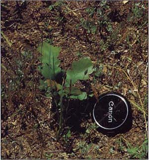
Oak seedlings less than 1 foot in height were found on 39% of the sample plots in Shasta and Tehama counties following firewood harvest.
In Tehama County, growth exceeded harvest by 3% for the 4 years of the survey (fig. 1). This approximate balance between growth and harvest indicates that for the short term, hardwood rangelands for the county as a whole are expected to remain fairly stable. In Shasta County, harvest levels exceeded growth by 30%, indicating that current harvest levels will decrease volumes per acre and canopy cover. These levels of harvest likely would not be sustainable given the expected growth rates of the residual trees and the unharvested areas.
Impacts on stand structure
A relatively small percentage of hardwood rangeland acreage was harvested statewide, based on the 4-year aerial observation. On a statewide basis, the annual acreage of firewood harvest amounted to slightly more than 6,000 acres. This is significantly less than the 30,000 acres estimated by IHRMP and U.S. Forest Service to be converted each year to residential or commercial development. The regional impacts of firewood harvesting appear to be concentrated in the northern Sacramento Valley.
Volume and crown cover of hardwood rangelands are only one measure of impact from firewood harvest. To provide baseline information on hardwood rangeland stand structure following firewood harvesting, a study was initiated in 1993. The study, funded by the CDF, was conducted at the ranch level by IHRMP and Cooperative Extension offices in Shasta and Tehama counties. It assessed the intensity of harvesting that has taken place in the past 10 years, the effectiveness of regeneration by seedling and stump sprouting, changes in wildlife habitat elements, and other stand structure characteristics. We also evaluated specific site factors to assess the spatial distribution of areas with adequate or inadequate regeneration.
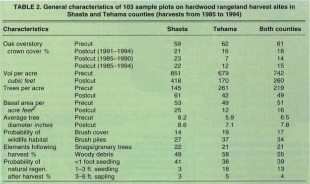
TABLE 2. General characteristics of 103 sample plots on hardwood rangeland harvest sites in Shasta and Tehama counties (harvests from 1985 to 1994)

Fig. 1. Comparison of harvest and growth on hardwood rangelands in Shasta and Tehama counties, fall 1988 to fall 1992.
This information will help in evaluating the effectiveness of current oak firewood harvesting practices on the long-term sustainability of the hardwood range resources in the Northern Sacramentc Valley foothills.
Nineteen sample ranches were randomly selected — 12 ranches in Tehama County and seven in Shasta County — in areas that had been harvested over the past 10 years. Information was collected from each study area on specific harvest location, date harvested, rainfall, soils, oak site index, precut and postcut canopy cover and diameter distribution, species composition and management practices. Data were collected on overstory trees, brush, stumps and resprouts in five to seven 1/10-acre circular plots randomly located within each harvested area. A belt transect was established at each plot to assess seedling regeneration and brush cover. Additional data were collected at each plot on wildlife habitat elements, including snags, dead and down woody material, number of cavities and acorn production.
Table 2 shows the initial results from 103 sample plots on the 19 ranches. Average preharvest canopy cover in the two counties was fairly similar. However, preharvest volume levels and average tree size were higher in Shasta County. In general, harvest intensity was higher in Tehama County, with the average residual canopy lower than in Shasta County. There has been a trend, however, of increasing residual canopy level over the last 4 years in Tehama County. This may well reflect the success of educational programs presented at the local level by Cooperative Extension and other agencies. The average residual canopy in Shasta County was not significantly less than the 25% minimum threshold discussed in the IHRMP's guidelines.
Aerial reconnaissance was carried out to evaluate preharvest and postharvest oak canopy between 1988 and 1992.
There was a fairly high probability for stump sprouting of trees cut on hardwood rangelands in the two counties (fig. 2). Overall stump sprouting averaged more than 54%. There was a strong negative correlation between stump diameter and sprouting success. Future studies will attempt to determine other site and management factors influencing sprouting success. There was an extremely low percentage of plots with naturally regenerated seedlings over 1 foot in height (table 2). This low probability, coupled with a slow growth rate, seems to suggest that stump sprouting will be the dominant method of regeneration in these stands following firewood harvest.
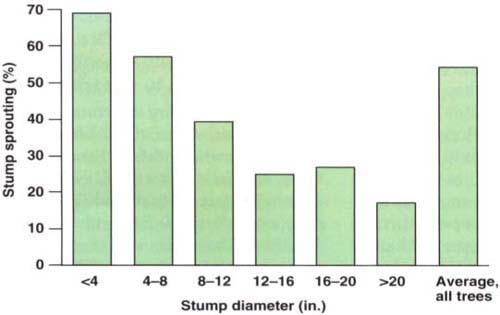
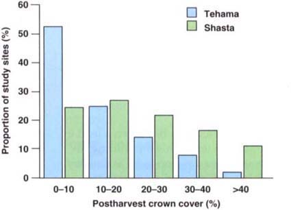
Fig. 3. Distribution of postharvest crown cover of 103 sample sites following firewood harvesting in Shasta and Tehama counties (harvests from 1985 to 1994).
Residual oak canopy cover ranged from 0 to 50% following firewood harvest in Shasta and Tehama counties.
The overall effect of this general sprouting percentage and poor natural seedling regeneration is that these levels of oak harvest will result in hardwood rangeland stands with a lower crown density, fewer trees per acre, and a larger average tree size. Changes in overstory canopy also resulted in a higher proportion of harvested areas with dead and down woody debris and brush piles. Approximately 20% of the harvested plots had snags or granary trees, which could be used by wildlife. The effect of these stand level changes on biological diversity will be addressed in future studies.
Policy direction
Tehama County has taken a lead in the state in using this monitoring information to develop local, voluntary oak harvesting guidelines on hardwood rangelands. The county board of supervisors appointed an oak harvest committee to develop a county conservation strategy, which was adopted by the board in 1994. Because of the major impact of firewood harvesting in the county, the main emphasis of the policy was on firewood harvesting and retention standards. Shasta County followed suit, and has passed a voluntary oak management policy that will form the basis of its educational outreach.
Both the Shasta and Tehama counties resolutions call for a retention of 30% crown cover following firewood harvest. This retention level attempts to balance the needs for profitable livestock management with wildlife habitat needs. For Tehama County, less than 10% of the sample plots harvested in the past 10 years had over 30% canopy retention (fig. 3). For Shasta County, slightly more than 25% of the sample plots had over 30% canopy cover. Both county resolutions also call for educational outreach to convey these voluntary guidelines to landowners. Shasta and Tehama counties already have mailed a copy of their guidelines to all landowners of hardwood rangelands in the county. Increasing the proportion of stands that meet these locally derived retention standards is one measure of the success of this outreach. An increase in canopy retention in Tehama County over the past 5 years (from 7% to 16% retention) is a good indication that landowners are receptive to such efforts.
These assessments show that from a statewide perspective firewood harvest is not a dominant factor affecting hardwood rangelands. Regional differences in the sources of impacts to hardwood rangelands were well documented at 1993 Board of Forestry hearings on hardwood rangelands. On the basis of this information, the board decided to direct local governments to develop their own policies to conserve hardwood rangelands, rather than pass statewide regulations that might not apply to most of the state. Similar local voluntary initiatives are being developed in several other counties. These include countywide ordinances on tree removal, modifying the open space requirements of the county general plan to address hardwood range-lands, and developing hardwood rangeland criteria for California Environmental Quality Act review of specific projects, depending upon local factors that jeopardize the sustain-ability of hardwood rangelands.
It is critical that counties continue to monitor trends in harvest, regeneration and stand structure on hardwood rangelands. Data such as that gathered in the studies described here can help determine whether existing local policies are accomplishing the goal of conserving the public values derived from privately owned hardwood rangelands.
Citations
Impact of firewood harvesting on hardwood rangelands varies with region

