California Agriculture
University of California
California Agriculture

All Issues

Biodiversity Council aids land use planners

Share using any of the popular social networks Share by sending an email Print article

Authors

Editors

Publication Information

California Agriculture 49(6):10-10.

Published November 01, 1995

PDF  |  Citation  |  Permissions

Full text

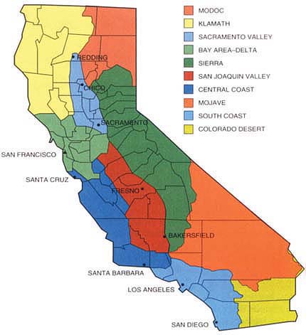
Scientists divide California into at least 10 bioregions with characteristic drainages, topography, climate and habitat types. But the boundaries between these bioregions seldom coincide with the legal and administrative boundaries of local governments and other agencies. Moreover, habitat management has typically been a piecemeal affair, driven by the need to protect individual threatened or endangered species.

To help develop a statewide ecosystem-based plan for conserving biodiversity, the California Resources Agency created the California Biodiversity Council in 1991. “The Council is a forum for all interests including agriculture to coordinate protection and sustainable use of resources,” says Resources Agency Secretary Douglas Wheeler, who chairs the Council.

The Council's 35 other members include representatives of federal and state natural resources agencies, county boards of supervisors, resource conservation districts, and the University of California.

To help local planners find the conservation information they need, the Resources Agency developed the California Environmental Resources Evaluation System (CERES), a database which integrates existing systems and makes them accessible to all Californians via the Internet. CERES includes census and land-ownership databases; vegetation and wildlife databases; and information about the physical environment from rainfall to geologic formations.

In contrast to species-by-species planning, comprehensive environmental planning will conserve both endangered species and those that are not yet endangered, says Wheeler. Thus, the Biodiversity Council encourages planning on a multi-species and watershed basis. The Council now facilitates planning for nearly 80 watershed groups statewide.

So far, the Council has focused on four of California's ten bioregions. Some results follow.

Bay-Delta.

The largest estuary on the West Coast, the San Francisco Bay/Sacramento-San Joaquin Delta Estuary has 40,000 acres of wetlands and 120 species of fish, and provides water for 20 million people and the production of 45% of the nation's fruits and vegetables. In December 1994, urban, agricultural and environmental interests signed an interim agreement to stabilize the quality and amount of water in the Bay-Delta while long-term solutions are worked out (see p. 77 ).

South Coast.

The Natural Community Conservation Planning (NCCP) program is a large-scale Habitat Conservation Plan designed to protect multiple species and their habitat. California has the first NCCP in the country, a pilot program that focuses on conserving coastal sage scrub in Southern California. This habitat is home to the California gnatcatcher and about 90 other potentially threatened or endangered species. Because coastal sage scrub is in a highly urbanized part of the state, the habitat is highly fragmented and scattered over more than 6,000 square miles in San Diego, Orange, Riverside, San Bernardino and Los Angeles counties.

Klamath.

Some North Coast salmon runs have declined drastically in recent years, devastating commercial fisheries. Notably, the coho salmon run has dropped from a high of 500,000 about 50 years ago to about 5,000 in 1994. Protecting watersheds is critical to protecting salmon. For example, road building can disturb natural drainage patterns, resulting in erosion and the consequent buildup of sediment that can choke the streams where salmon spawn. Using the South Coast NCCP pilot program as a model, the state is working to develop a comprehensive approach to managing Northwestern California's natural resources.

California has at least 10 ecosystem-based bioregions, shown above. The boundaries between bioregions seldom coincide with legal and administrative boundaries of local agencies. (Map courtesy of the California Biodiversity Council)

California has at least 10 ecosystem-based bioregions, shown above. The boundaries between bioregions seldom coincide with legal and administrative boundaries of local agencies. (Map courtesy of the California Biodiversity Council)

Sierra Nevada.

Protecting watersheds will also help conserve biodiversity in the Sierra Nevada bioregion. So far, the focus has been on the American River, South Fork, Kern River and Fresno River watersheds. In addition to reducing the erosion of sediment into streams, participants are restoring urban waterways by, for example, clearing cars, grocery carts and other sorts of debris out of rivers, and landscaping stream banks with native plants, which will stabilize the banks and provide habitat for wildlife.

“Agriculture has played an important role in each of these biodiversity projects,” says Wheeler. “If agricultural land contributes to biodiversity, then agriculture is preferable to development for residential purposes. The state is looking for ways to involve local agricultural landowners.”

Editor

Return to top

Biodiversity Council aids land use planners

Webmaster Email: sjosterman@ucanr.edu

Biodiversity Council aids land use planners

Share using any of the popular social networks Share by sending an email Print article

Authors

Editors

Publication Information

California Agriculture 49(6):10-10.

Published November 01, 1995

PDF  |  Citation  |  Permissions

Full text

Scientists divide California into at least 10 bioregions with characteristic drainages, topography, climate and habitat types. But the boundaries between these bioregions seldom coincide with the legal and administrative boundaries of local governments and other agencies. Moreover, habitat management has typically been a piecemeal affair, driven by the need to protect individual threatened or endangered species.

To help develop a statewide ecosystem-based plan for conserving biodiversity, the California Resources Agency created the California Biodiversity Council in 1991. “The Council is a forum for all interests including agriculture to coordinate protection and sustainable use of resources,” says Resources Agency Secretary Douglas Wheeler, who chairs the Council.

The Council's 35 other members include representatives of federal and state natural resources agencies, county boards of supervisors, resource conservation districts, and the University of California.

To help local planners find the conservation information they need, the Resources Agency developed the California Environmental Resources Evaluation System (CERES), a database which integrates existing systems and makes them accessible to all Californians via the Internet. CERES includes census and land-ownership databases; vegetation and wildlife databases; and information about the physical environment from rainfall to geologic formations.

In contrast to species-by-species planning, comprehensive environmental planning will conserve both endangered species and those that are not yet endangered, says Wheeler. Thus, the Biodiversity Council encourages planning on a multi-species and watershed basis. The Council now facilitates planning for nearly 80 watershed groups statewide.

So far, the Council has focused on four of California's ten bioregions. Some results follow.

Bay-Delta.

The largest estuary on the West Coast, the San Francisco Bay/Sacramento-San Joaquin Delta Estuary has 40,000 acres of wetlands and 120 species of fish, and provides water for 20 million people and the production of 45% of the nation's fruits and vegetables. In December 1994, urban, agricultural and environmental interests signed an interim agreement to stabilize the quality and amount of water in the Bay-Delta while long-term solutions are worked out (see p. 77 ).

South Coast.

The Natural Community Conservation Planning (NCCP) program is a large-scale Habitat Conservation Plan designed to protect multiple species and their habitat. California has the first NCCP in the country, a pilot program that focuses on conserving coastal sage scrub in Southern California. This habitat is home to the California gnatcatcher and about 90 other potentially threatened or endangered species. Because coastal sage scrub is in a highly urbanized part of the state, the habitat is highly fragmented and scattered over more than 6,000 square miles in San Diego, Orange, Riverside, San Bernardino and Los Angeles counties.

Klamath.

Some North Coast salmon runs have declined drastically in recent years, devastating commercial fisheries. Notably, the coho salmon run has dropped from a high of 500,000 about 50 years ago to about 5,000 in 1994. Protecting watersheds is critical to protecting salmon. For example, road building can disturb natural drainage patterns, resulting in erosion and the consequent buildup of sediment that can choke the streams where salmon spawn. Using the South Coast NCCP pilot program as a model, the state is working to develop a comprehensive approach to managing Northwestern California's natural resources.

California has at least 10 ecosystem-based bioregions, shown above. The boundaries between bioregions seldom coincide with legal and administrative boundaries of local agencies. (Map courtesy of the California Biodiversity Council)

California has at least 10 ecosystem-based bioregions, shown above. The boundaries between bioregions seldom coincide with legal and administrative boundaries of local agencies. (Map courtesy of the California Biodiversity Council)

Sierra Nevada.

Protecting watersheds will also help conserve biodiversity in the Sierra Nevada bioregion. So far, the focus has been on the American River, South Fork, Kern River and Fresno River watersheds. In addition to reducing the erosion of sediment into streams, participants are restoring urban waterways by, for example, clearing cars, grocery carts and other sorts of debris out of rivers, and landscaping stream banks with native plants, which will stabilize the banks and provide habitat for wildlife.

“Agriculture has played an important role in each of these biodiversity projects,” says Wheeler. “If agricultural land contributes to biodiversity, then agriculture is preferable to development for residential purposes. The state is looking for ways to involve local agricultural landowners.”

Editor

Return to top


University of California, 2801 Second Street, Room 184, Davis, CA, 95618
Email: calag@ucanr.edu | Phone: (530) 750-1223 | Fax: (510) 665-3427
Website: https://calag.ucanr.edu