


All Issues
Advanced technology provides insight into marine habitats
Publication Information
California Agriculture 51(4):41-43. https://doi.org/10.3733/ca.v051n04p41
Published July 01, 1997
PDF | Citation | Permissions
Abstract
The pattern of boom and bust in major commercial fisheries has occurred many times around the world, and always with major economic consequences. A classic example is the sardine fishery in Monterey Bay. At the sardine fishery apex in the 1930s and 1940s, more than 100 vessels harvested 700,000 tons of sardines and sold them to 19 canneries and 20 reduction plants — the largest assemblage of seafood processors in the Western Hemisphere. By 1952 the sardine population had plummeted, the fishery had collapsed and most of the canneries had closed.
Full text
The pattern of boom and bust in major commercial fisheries has occurred many times around the world, and always with major economic consequences. A classic example is the sardine fishery in Monterey Bay. At the sardine fishery apex in the 1930s and 1940s, more than 100 vessels harvested 700,000 tons of sardines and sold them to 19 canneries and 20 reduction plants — the largest assemblage of seafood processors in the Western Hemisphere. By 1952 the sardine population had plummeted, the fishery had collapsed and most of the canneries had closed.
Unfortunately, we are today seeing more and more examples of the bust side of the cycle. World catch of marine fishes peaked in 1989; since then dramatic declines have occurred in most of the world's most productive fisheries. Many of the collapses occurred before sufficient information was available for proper management. Often, fisheries grew and collapsed without knowledge of the basic biology and habitat requirements of important species.
In response to this need for information, Richard Starr, UC Sea Grant Extension Program Marine Advisor, and Gary Greene, director of California State University's Moss Landing Marine Laboratories (MLML), established the Center for Habitat Studies at MLML in 1995. The Habitat Center is a cooperative venture between the University of California Sea Grant Extension Program, MLML and the new campus of the California State University at Monterey Bay. Its purpose is to bring together scientists who use advanced technologies to provide insights into the spatial distribution and ecological value of coastal and marine resources.
A multidisciplinary team of marine researchers has formed at the Center to study habitat relationships of rock-fishes, a diverse group that is one of the mainstays of commercial and recreational fisheries on the West Coast. The team deploys geophysical tools such as sidescan sonar to locate and characterize habitats on a large scale, then collects biological information using a manned submersible and acoustic equipment to quantify specific associations between species and habitats.
Greene, a geologist, leads the geophysical work. He has collected and analyzed sonographs of the seafloor, ranging from shallow water to the great depths of the Monterey Canyon. The sonographs enable us to target locations that are likely to contain rockfishes. Once rockfish habitats are identified, biologist Mary Yoklavich of the Pacific Fishery Environmental Group (part of the National Marine Fisheries Service) uses a manned submersible to collect biological observations. The submersible's pilot and a scientist conduct visual strip transects to identify species, describe fish behavior and count the number of animals observed in each transect. Paired lasers attached to the submersible are used to estimate fish length. The transect is also videotaped., and technicians painstakingly transcribe information about habitats and the exact location of every fish seen. Ichthyologists Gregor Cailliet from MLML, Bob Lea from the California Department of Fish and Game and Milton Love from UC Santa Barbara help identify species and provide ecological expertise.

Fig. 1. Computerized geographic Information systems are used to map the water depth and bottom types of Monterey Bay.
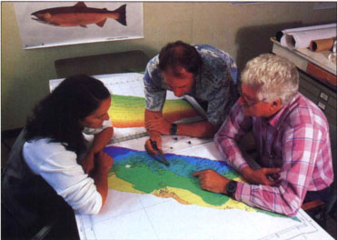
Marine advisor Rick Starr, center, and fellow marine scientists Gary Greene and Mary Yoklavich look at a full-color, GIS-generated map of the ocean floor at the Center for Habitat studies in Moss Landing.
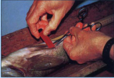
An acoustic transmitter is surgically implanted into the abdominal cavity of a rockfish.
Starr directs the next phase of analysis: the combination of ecological and biological data using geographic information system (GIS) technology (fig. 1). Computerized GIS systems are used to map bathymetry, habitats and rockfish distributions. Early results of the team's research indicate that rocky outcrops associated with undersea canyons form natural refugia — places where fish are protected from harvest. We observed that these relatively unfished habitats contained larger and more diverse species of rockfishes than did heavily fished areas. The differences between heavily fished and lightly fished habitats led us to evaluate the potential of marine fishery reserves to enhance fisheries.
Marine fishery reserves are currently being proposed as alternatives to traditional fishery management practices in many places around the world ( see page 33 ). Harvest refugia may enhance fisheries by increasing fish abundance and reproductive output in the reserve; contributing to recruitment inside and outside the protected area; maintaining species, genetic and habitat diversities; reducing user conflicts; and providing opportunities to field test ecological concepts related to protected areas.
The scientific community is divided in its debate over the value of refugia to enhance adjacent fisheries, however, because many of the fundamental assertions have not been tested. For example, a key assumption of reserve theory is that fish will remain in a reserve long enough to grow and reproduce, and that younger fish will ultimately “spill over” to unprotected areas and thus enhance local fisheries.
At the Center for Habitat Studies, we are conducting several research projects to evaluate reserve theory and provide information for fishery managers. We recently completed sidescan sonar surveys in the Big Creek Ecological Reserve to map benthic fish habitats inside and adjacent to the reserve. We next plan to use a submersible to estimate species composition, abundance and species/habitat relationships inside and adjacent to the reserve. This information will be used with information about ocean circulation to estimate the reproductive capability of rockfishes in the reserve.
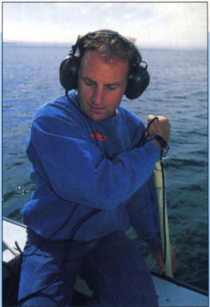
Using global positioning system (GPS) coordinates, Starr tracks the tagged rockfish to determine their home ranges and frequency of movements.
As a second method of evaluating the effectiveness of reserves as a refuge for adult rockfishes, we are identifying home ranges and rates of movements of fishes in a proposed underwater park off Cannery Row and on the edge of the Monterey undersea canyon. We do this by first capturing and anesthetizing rockfish, then surgically implanting an acoustic transmitter into the abdominal cavity of each animal. We release the fish where they were caught, using differential global positioning system (GPS) coordinates, and track them with hydrophones to determine their home ranges and frequency of movements.
Our research at the Habitat Center should lead to better understanding of the value of marine reserves and their potential for enhancing fisheries. We expect that the results will directly contribute to the effective management of marine fishery reserves in California and provide valuable information to fishery managers in all parts of the world.
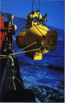
The submersible's pilot and a scientist conduct visual strip transects of rockfish habitats to identify species, describe fish behavior and count the number of rockfish observed in each transect.
References
McEvoy AF. The Fisherman's Problem: Ecology and Law in the California Fisheries, 1850–1980. 1986. New York: Cambridge Univ Pr.
Rowley RJ. Marine reserves in fisheries management. Aquar Conserv: Marine Freshwater Ecosys. 1994. 4:233-54. doi:10.1002/aqc.3270040305 https://doi.org/doi:10.1002/aqc.3270040305
Starr RM, Fox DS, Hixon MA, et al. Comparison of submersible and acoustic estimates of fish density on a rocky bank. Fish Bull. 1996. 94:113-23.
Yoklavich MM, Cailliet GM, Greene HG, Sullivan D.. Interpretation of sidescan sonar records for rockfish habitat analysis: Examples from Monterey Bay. Alaska Dept. Fish and Game Special Publication No. 1995. 9:11-5.
Advanced technology provides insight into marine habitats

