


All Issues
Dry-season soil water repellency affects Tahoe Basin infiltration rates
Publication Information
California Agriculture 64(3):141-148. https://doi.org/10.3733/ca.v064n03p141
Published July 01, 2010
PDF | Citation | Permissions
Abstract
Lake Tahoe's declining clarity makes the identification of runoff and erosion sources and evaluation of control measures vitally important. We treated relatively undisturbed, native, forested sites of 10% to 15% slope with surfactant and used a rainfall simulator to investigate the effects of repellency. We compared infiltration measurements made by the simulator and a mini-disk infiltrometer (MDI). Runoff was produced by all plots with untreated water, but only two of 12 plots with surfactant. At volcanic soil sites, infiltration rates using surfactant exceeded those with water by only 20% when there was little litter cover, but with substantial litter the infiltration rates increased threefold. Similarly, at the granitic soil sites surfactant-enhanced infiltration rates were four times greater with scant litter, and eight times greater with substantial litter cover. Postsimulation soil moisture content and wetting depths were greater with the surfactant treatment. Excavations under surfactant treatments revealed that discontinuities in the soil's hydrophobic organic layer resulted in preferential infiltration zones in the mineral soils below.
Full text
Lake Tahoe is a spectacular, deep mountain lake of exceptional clarity, historically maintained due to low nutrient (ultraoligotrophic) conditions. Since continuous water-quality monitoring began in the early 1960s, algal growth has increased by more than 5% per year, with a corresponding 1-foot-per-year decline in water clarity.

Lake Tahoe's famed clarity is declining due to increases in sediments and nutrients, which coincide with nearly a half-century of urban growth in the region. Soil repellency may be a factor contributing to erosion and runoff into the lake.
The consensus among researchers is that: (1) the documented decline in clarity coincides with more than 40 years of growth in urban areas (now 10% of total land area), which contribute 72% of fine particles to the lake (TERC 2008); (2) lake-floor sediment accumulations correspond with periods of human activity (Heyvaert 1998); (3) annual phosphorus loading to the lake depends directly on sediment concentrations (Hatch 1997); and (4) fine (1 to 8 microns [???]) particles diminish the lake's clarity by transporting adsorbed nutrients and scattering light while in suspension (Swift et al. 2006). Understanding the sources, transport and means of controlling fine-particle delivery is essential to stem the water quality decline.
Infiltration, runoff and erosion near Tahoe have been studied extensively, yet knowledge of repellent (hydrophobic) soil conditions often remains anecdotal or oversimplified. Soil water repellency can be induced by fire (Doerr et al. 2010) and also occurs during late-season dry conditions. The commonly acknowledged paradigm that hydrophobicity is responsible for greater runoff and erosion after fires (Robichaud 2000), while accurate in some locales, has not always been verified (Doerr and Moody 2004).
Larsen et al. (2009) noted that high-severity fires alter the vegetative cover and characteristics of mineral soil, making it difficult to separate the effects of fire-induced soil water repellency from other changes in soil characteristics and surface cover. In the Western states, Pierson et al. (2008) found that repellency was greatest on unburned slopes and that dry-season variability had a more substantial impact than fire. Postfire hydrologic responses were not attributed to intensified repellency, but rather to the increased connectivity of runoff sources following the removal of vegetation and soil cover. Seasonal, non-fire-induced repellency has been considered a function of soil moisture, but its recurrence following wet periods appears to depend not only on soil drying, but also on input or the redistribution of hydrophobic substances (Doerr and Thomas 2000).

Researchers studied soil repellency with and without surfactant treatments at four sites in the Lake Tahoe Basin.
The realization that few studies actually isolated the hydrologic effects of repellency prompted new research directions. Leighton-Boyce et al. (2007) modified earlier methods developed in Southern California, in which surfactants were applied during rainstorms on burned slopes. Surfactants may be used as wetting agents to induce infiltration and mimic normal infiltration conditions. The 2007 study in Portugal used surfactant-treated water in a rainfall simulator to isolate hydrophobic effects.
We investigated plot-scale hydrologic responses — including infiltration, runoff and sediment yield — due to seasonal hydrophobicity at four relatively undisturbed, native, forested sites in the Tahoe Basin (fig. 1). (The entire basin was logged in the 1850s, and partially again in the 1920s.) We present baseline hydrologic responses to repellency that may be used for comparison to similar data gathered at disturbed sites targeted for erosion-control measures. Data from two infiltration measurement devices, a rainfall simulator and the more readily deployed mini-disk infiltrometer (MDI), was also compared and evaluated.

Lake Tahoe study areas
The Truckee and Blackwood Canyon sites had volcanic soil, and Bliss State Park and Meyers road cut were granitic. The sites were similar in slope (10% to 15%), and rainfall simulations had been conducted previously at all four under similar conditions to those considered here (Grismer et al. 2009) (table 1).
Surfactants reduce water surface tension, are commonly used (e.g., detergents) and generally nontoxic. We modified methods presented by Leighton-Boyce et al. (2007), and used Pro-Spreader Activator surfactant (Target Specialty Products, Fresno, Calif.) mixed with available groundwater to a concentration of 0.25%, the upper limit of the manufacturer's recommendation. Initial field tests showed that this concentration was suitable to induce infiltration through repellent soils in the Tahoe Basin.
After plots were established at each site, we measured initial soil moisture (Campbell Scientific TDR moisture meter) and soil strength (cone penetrometer depth to refusal, 350 pounds per square inch).
Following the artificial rainfall test to determine infiltration and runoff rates, moisture and density (using cone penetrometer depths as an index) were again measured along with litter depth and composition, which was visually estimated. Measurements were taken with an MDI in areas adjacent to the rainfall-simulator plot frames at each site. Soils were hand-excavated to 10 inches, to observe wetting patterns and depths.
The rainfall-simulator tests were also slightly modified from the description by Grismer and Hogan (2004). Without foreknowledge of the treatment to be applied, 6.9-square-foot (0.64-square-meter) plot frames were installed, and simulated rainfall was applied at 4.7 inches per hour (120 millimeters per hour) for the duration necessary to produce steady runoff and fill sequential 6-ounce (175-milliliter) sample bottles. This sometimes took more than 70 minutes.
Rainfall simulations. Infiltration rates were calculated as the difference between the applied rainfall and runoff rates, and were assumed to be greater than the application rate when no runoff occurred. Three replicates of each treatment were conducted at each site for a total of 24 rainfall simulations. Following a series of surfactant treatment simulations, all equipment was cleaned with a mild bleach solution prior to the untreated-water simulations. Collected runoff samples were filtered in the lab (Whatman #541 and 0.45-micron filters). The sediment samples were oven-dried at 221°F (105°C) and then combusted at 806°F (430°C) to determine organic matter content (Grismer et al. 2008).
MDI. An MDI (Decagon Devices, Pullman, Wash.) was also used at each site to determine infiltration rates. These devices have been deployed by the U.S. Forest Service to evaluate hydrophobicity. Water held in a chamber resembling a graduated cylinder infiltrates when suction is sufficient to break surface tension across a porous disk at the base (Robichaud et al. 2008). The constant-head (water level) adjustment was set at 0.79 inch (20 millimeters), and measurements were taken for 1 minute with the difference in volume used to calculate the infiltration rate. At each site surfactant and untreated water were each replicated 10 times.

Smaller sequential samples were also collected for texture analysis. The Coulter LS-230 particle-size analyzer uses laser-light scattering to produce particle-size distributions by volume. A revised version of the protocol developed by Eshel et al. (2004) was used to process the runoff samples. In the field, we collected 48 runoff samples from both volcanic and granitic sites and made composites for each site as needed for the analyses.
Statistics. Factorial analyses were conducted to test for significant interactions between site and treatment effects for rainfall simulation, MDI and particle-size distribution. For the rainfall simulation results this interaction was nonsignificant, providing the rationale to use a randomized design. No transforms were required to achieve normality. Infiltration rates by site and treatment were separated using Tukey's HSD test. The Spearman correlation was used to test for the correlation between rainfall simulator and MDI infiltration results. MANOVA repeated measures analysis was used to detect significant changes in some soil conditions following the rainfall simulations.
Analytical findings
We considered the results in terms of soil, runoff, infiltration and particle-size distribution. The soil section included measurements of several soil properties, which were repeated to test for changes before and after rainfall simulations. Runoff timing, sediment yield and organic matter content were contrasted between the two treatments (surfactant and untreated water). Infiltration rates were compared between and within (by treatment) each site for both methods. The MDI and rainfall-simulator data were also compared. Finally, particle-size distribution analysis revealed differences by soil type and any correlations between particle-size fractions and infiltration.
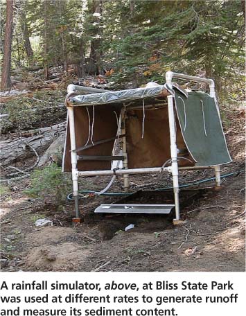
A rainfall simulator, above, at Bliss State Park was used at different rates to generate runoff and measure its sediment content.

Soils. Soil physical properties were measured before and after each treatment (table 2). Mulch depth did not differ significantly by site or treatment. Cone penetrometer depths, used as an index of soil strength, usually slightly increased following treatment, presumably as a result of increased soil moisture. The within-subjects MANOVA test comparing the results of depth-to-refusal measurements before and after treatments resulted in nonsignificant differences between means — thereby removing treatment as a variable affecting soil strength.
Averaged initial soil-moisture levels ranged between 1.6% and 3.0%. At all sites except Blackwood Canyon (volcanic soil), surfactant treatments resulted in higher final soil-moisture levels than untreated water. This difference was most pronounced on granitic soils, where postsimulation soil moisture was more than four times higher with surfactant than with water at Bliss, and three times higher at Meyers. The depth to continuous wetting differed significantly by soil type (P = 0.0355), treatment (P < 0.0001) and soil type/ treatment interaction (P = 0.0078).
At every site, the surfactant caused deeper wetting than untreated water. The untreated water was more effective in wetting volcanic soils than granitic soils, which were nearly completely resistant to wetting (these soils had significantly less wetting with untreated water than the other soil type/ treatment combinations). When surfactant was used, the virtually unwettable granitic soils were wetted to a depth of approximately 6 inches (15 centimeters). While dry “pockets” or layers above wetted soil were observed at all sites, preferential flow was most obvious at Meyers with the surfactant treatment.
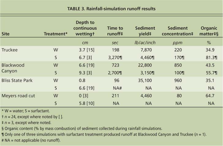
Runoff. The effectiveness of surfactant treatment on runoff rates was obvious in the field and samples collected during runoff simulation (table 3); runoff was produced by all 12 untreated-water plots, but only two of 12 plots that received surfactant. The lack of runoff data from many surfactant plots made the statistical analysis of some variables difficult or impossible, but several comparisons are worth noting.
While the granitic soils produced no runoff when surfactant was used, each of the volcanic soils produced runoff from one surfactant treatment plot. Though runoff occurred from these two plots with surfactant treatment, the time to runoff was different. At Truckee, the single runoff-producing surfactant plot took 16 times longer to run off than the average time for the untreated-water plots. At Blackwood Canyon, the surfactant required about four times longer to produce runoff than the average from the untreated-water plots. Sediment yield and concentration was highest at Bliss State Park, followed by the Blackwood Canyon, Truckee and Meyers road cut sites. Comparison of similar soil types showed that Blackwood Canyon produced about four times as much sediment as Truckee, while runoff from Bliss contained more than seven times as much sediment as Meyers. Runoff sediment organic-matter fractions were highest at Meyers (65%), followed by Blackwood Canyon (44%) then Bliss and Truckee (35%).
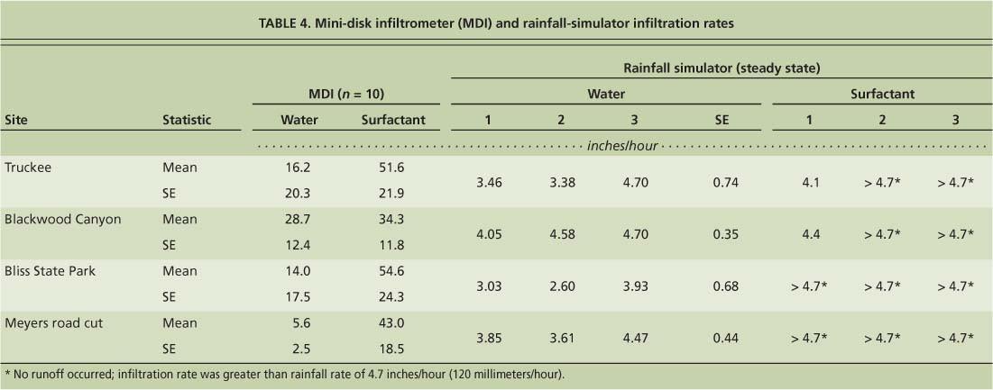
Infiltration. Rainfall-simulator-determined infiltration rates differed significantly by treatment at the Bliss site only (table 4). Factorial analysis revealed a significant interaction between site and treatment for the MDI results; treatment had different effects depending on the site. Additional analyses indicated that there was also an interaction between treatment and soil type, suggesting that whatever controlled the treatment effect at different sites was associated with soil type.
This was also confirmed by a similar treatment effect at the granitic sites, although Truckee and Blackwood differed from one another. Water treated with surfactant infiltrated much more efficiently than untreated water at all sites except Blackwood (P = 0.2747), where the infiltration rate with surfactant exceeded that for water by only 20%. The surfactant rate was greater than the untreated-water rate by a factor of about three at Truckee (P = 0.0029), four at Bliss (P = 0.0003) and eight at Meyers (P < 0.0001). The greatest infiltration rate was found at Blackwood Canyon using untreated water, but that site had the lowest rate with surfactant. The untreated-water infiltration rate at Blackwood was about twice that of Truckee or Bliss, and five times higher than at Meyers. Surfactant infiltration rates at Bliss and Truckee, which were nearly equal, were 25% higher than those at Meyers and 60% higher than Blackwood Canyon. MDI infiltration rates were much greater than those from the rainfall simulator, though they were significantly correlated (Spearman R = 0.83).
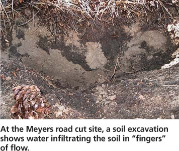
At the Meyers road cut site, a soil excavation shows water infiltrating the soil in “fingers” of flow.

At the Truckee site, dry patches or layers of organic material remained above the wetted mineral soil.
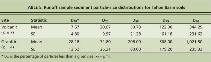
Particle-size distributions. As found by Grismer et al. (2008), volcanic soils were much finer than granitic soils at each particle-size percentile (D10, D25, D50, D75, D90), and particle sizes differed significantly by soil type (table 5). Volcanic particles were typically about one-fourth the size of granitic particles. Ten percent of particles occurring in runoff from volcanic soils were less than 8 ???, a size fraction considered detrimental to lake clarity (Swift et al. 2006). The relationship between particle-size distribution and infiltration rate appeared to be nonlinear, making the Spearman correlation an appropriate test. All particle sizes were strongly, negatively correlated with infiltration rates. For the rainfall-simulator-based infiltration rates, Spearman correlations for the D10, D25, D50, D75 and D90 particle sizes were R = −0.86, −0.91, −0.83, −0.89 and −0.69, respectively; similarly, for the MDI-based infiltration rates, the Spearman correlations were R = −0.80, −0.70, −0.74, −0.68 and −0.76, respectively.
Surfactants and repellency
Differences in infiltration rates due to the surfactant treatment were unmistakable, as rates always increased — by a statistically significant margin at one site for the rainfall simulators, and at three of four sites for the MDIs. Increased infiltration rates with surfactants demonstrated the importance of soil hydrophobicity to possible runoff and erosion, and, if surfactant is a good model of wettable conditions, that repellency has a substantial effect on infiltration rates into mineral soil. However, the infiltration rates found with the MDI remained very high with untreated water, suggesting that the persistence of repellency in mineral soil upon contact with water is minimal. Much lower infiltration rates resulted from the rainfall simulators when native covers were maintained. Therefore, surfactant efficacy and the actual magnitude of the infiltration rate depended to a large degree on the soil cover conditions.
Surface litter. Surface litter layers were an important factor affecting wetting patterns following rainfall simulation. Native litter cover was most substantial at Truckee and Meyers. Beneath a layer of identifiable pine needle mulch was a layer of decomposed organic material (hemic/sapric < 16% plant material still discernible) with a high degree of fungal activity mats (fungal mycelia with organic matter). Excavations following rainfall simulation indicated that this layer was different from the pine needle mulch because it was neither a storage zone delaying runoff nor a structural barrier encouraging lateral rather than downward movement. The highly decomposed organic layer was strongly and persistently hydrophobic, restricting infiltration into the mineral soil below. Discontinuities in this layer were responsible for preferential flow and wetting.
These wetting patterns were most obvious at the sites with the most litter, Truckee and Meyers. “Fingered” flow was most evident in the Meyers surfactant plots, while at Truckee there was considerable wetting below a large, dry, mineral layer. In the finer-textured Truckee soil, it appeared that runoff had preferentially infiltrated several inches into the mineral profile and then began to wet upward via capillary action. Sites with less litter, Blackwood and Bliss, had correspondingly less developed or nonexistent decomposed organic layers. Infiltration was not as concentrated, and preferential zones were not as obvious, although upon excavation it was apparent that dry patches or layers of organic material remained above the wetted mineral soil.
Meeuwig (1971) originally underscored the litter layer's importance as an infiltration-limiting factor, linking eight distinct wetting patterns and corresponding infiltration curves on bare and covered sites northeast of Lake Tahoe. At forested sites, the hydrologic effects of mineral-soil repellency are at some level subsumed by those of the partially decomposed organic layer. The differences in wetting of mineral soil between treatments were most pronounced on coarse, granitic soils, indicating that hydrophobicity plays a more important role with these soils compared to volcanic soils. Granitic soils exhibited almost no wetting by untreated water, but about 6 inches (15 centimeters) of continuous and more than 10 inches (25 centimeters) of intermittent wetting with surfactant.

The texture and moisture content of soils at each site did not necessarily correlate with the degree of repellency found in the study. For example, at Blackwood Canyon infi ltration rates with untreated water in the finer-textured volcanic soils were twice as high as any other site, and the response to surfactant was relatively subdued.
Soil moisture and texture. The changes in soil moisture content also revealed the impact of the surfactant treatment on granitic soils. Following water treatment moisture contents doubled, but with the surfactant treatments they increased sixfold. The effects of soil texture on the establishment and degree of repellent conditions are complex. Coarse-textured soils have been associated with repellency because coarse particles have less surface area per unit volume than finer particles, making them more susceptible to coating by a limited supply of hydrophobic substances (Crockford et al. 1991). However, repellency is not exclusive to coarse soils; if fine-textured (25% to more than 40% clay) soils form aggregates (presumably with greater organic-matter content) they, too, are susceptible to the development of repellency conditions (Wallis et al. 1991). In some cases, very fine fractions have the highest degree of repellency (de Jonge et al. 1999).
Texture alone does not imply a degree of repellency because aggregation and the supply of hydrophobic material are controlled by many other factors; contradictions in the relationship between soil texture and repellency may also be due to confusion between the effects of texture and structure (Fox et al. 2007). Further confusion results because fine fractions are not necessarily associated with fine textures, nor are coarse fractions necessarily associated with coarse textures; the effects of soil aggregate formation must be considered. Fine-textured soils have exhibited the highest degree of repellency, while coarse soils appear to be more susceptible to developing fire-induced or other repellency (de Jonge et al. 1999; Doerr et al. 2000).
Though the Blackwood site comprised finer-textured volcanic soils with scant litter cover, its untreated-water infiltration rates (MDI) were nearly twice as high as those of any other site, and the response to surfactant was relatively subdued. The limited response to surfactant suggests that the litter at Blackwood was neither physically inhibiting infiltration nor providing hydrophobic substances adequate to coat the relatively fine mineral particles.
Untreated plots. All of our untreated-water plots produced runoff. At the volcanic soil sites, infiltration rates were similar to previous studies and ranged from 3.4 to 4.7 inches (86 to 119 millimeters) per hour at Truckee and 4.0 to 4.7 inches (103 to 119 millimeters) per hour at Blackwood. The average sediment concentrations were 0.22 gram per liter at Truckee and 0.85 gram per liter at Blackwood. In previous studies conducted on plots with pine needle cover at Bliss State Park, and at Rubicon on granitic Meeks series soils (about 60% slopes), infiltration rates were about 2 inches (51 millimeters) per hour, and sediment concentration was 1.21 grams per liter at both sites.
At Bliss, untreated-water plots yielded infiltration rates of 2.6 to 3.9 inches (66.0 to 99.8 millimeters) per hour and an average sediment concentration of 0.96 gram per liter from plots having much gentler slopes of roughly 12%. At Meyers in 2007, the average rainfall-simulator-measured infiltration rate of about 4 inches (100 millimeters) per hour was practically identical to that measured in this study.
Studying native forest sites
Ours is the first among recent rainfall-simulation projects to focus exclusively on native sites. In some cases, previously conducted rainfall simulations used lower application rates and the sites had different slopes, making comparisons difficult. Our Northstar (data not shown) and Truckee sites produced similar results where native cover was intact. These granitic sites generally had higher infiltration rates than those with volcanic soils, reinforcing the observed trend of susceptibility to hydrophobicity among coarse soils. Previous studies at Bliss conducted on steeper slopes and using a lower rainfall rate reported higher sediment concentrations, probably due to the greater slope (Grismer and Ellis 2006; Grismer et al. 2008).
Grismer et al. (2008) studied particle sizes in runoff from the Tahoe Basin. From disturbed soils, the D10 particle sizes were 70.4 μm (granitics) and 3.98 μm (volcanics), while the D90 particle sizes were 1,589 μm (granitics) and 1,227 μm (volcanics). These values are much larger than those found in our study (table 5). Although several factors, such as slope, influence particle-size distributions, this may indicate that soil cover is most effective in removing large particles from runoff. Comparison of particle sizes between water and surfactant treatments could be useful, but runoff from the surfactant plots did not provide adequate samples to allow for such analysis.
The MDI is easy to use and has become increasingly popular to determine field infiltration rates in the Tahoe Basin, suggesting that comparing rates from the MDI and rainfall simulator is valuable. The primary differences between the two are: (1) the MDI requires the removal of litter for the porous disk to form a seal with the mineral soil surface and (2) the MDI provides constant-head water pressure conditions at the surface, while the rainfall simulator produces constant flux at the surface. MDI-derived infiltration rates were several times greater than those from the rainfall simulator, not unlike those in early studies using the constant-head permeameter (“Amooz-a-meter” or Johnson permeameter) in the Tahoe Basin. We found a significant correlation between infiltration rates measured by both methods; however, those from the rainfall simulator were dramatically smaller than those from the MDI for water and surfactant treatments across all sites. In this study, higher infiltration rates measured by the MDI indicated the importance of the litter layer, which was confirmed by post-rainfall-simulator excavations.
An infiltrometer can provide a quantitative measure of flow rates to estimate a repellency index in the field. Generally, infiltrometers facilitate a more sensitive and physically meaningful field test than the water drop penetration test (WDPT). The U.S. Forest Service developed methods including the MDI for studying postfire infiltration (Robichaud et al. 2008) in which MDI and WDPT results were well correlated, allowing the use of existing WDPT repellency classifications to classify MDI results. MDI-measured infiltration rates of less than 9.5 inches (240 millimeters) per hour were considered strong repellency, while rates of 9.5 to 24.8 inches (240 to 630 millimeters) per hour were weak. Based on these classifications, repellency existed at both our granitic soil sites. It was strong at Meyers (5.7 inches [142 millimeters] per hour) and weak at Bliss (14.2 inches [356 millimeters] per hour) despite differences in the litter layers.
Similarly, there was weak repellency at the litter-thick Truckee site (16.2 inches [412 millimeters] per hour), but none at Blackwood (28.7 inches [728 millimeters] per hour). Surfactant seemed to confirm this classification of Blackwood, because infiltration only increased 20%; however, it is doubtful that repellency was truly weak at Truckee or Bliss, as use of the surfactant caused infiltration rates to triple or quadruple. Future use of MDI results in the Tahoe Basin to index repellency appears promising, but classifications based on the WDPT may not be the best option, especially in locations where decomposed surface cover is intact.
Following the Angora fire near South Lake Tahoe in 2007, the Lake Tahoe Basin Management Unit of the U.S. Forest Service (Tolley and Norman 2008) used the MDI method to assess postfire hydrophobicity. Interestingly, three of six sites had postburn infiltration rates (31.5 to 43.3 inches [800 to 1,100 millimeters] per hour) higher than any of the untreated-water infiltration rates recorded on unburned sites during our study. These sites experienced moderate to high burn severity, so their high infiltration rates may indicate that the heat was sufficient to mobilize or destroy substances causing repellency. Pierson et al. (2008) also suggested that burn temperatures reduced background repellency on several Western sites. Events such as the Angora fire may intensify hydrophobicity in some places while weakening it at others; hydrologic response is not simply due to intensified hydrophobicity, but also the loss of vegetation and cover.
Larsen et al. (2009) underscored that postburn hydrophobicity is patchy and dramatically decreases within a year after a fire, and that loss of soil cover appears to be the primary factor affecting postburn erosion rates. Future research in these areas would improve understanding of how fire behavior affects infiltration, runoff and erosion, allowing for the more precise identification of postburn erosion source areas.
Reducing particles in Lake Tahoe
To reduce the delivery of fine particles into Lake Tahoe, sources of these sediments and their means of transport must be identified. In previous studies, rainfall simulators were used to test for significant relationships between erosion and various site properties (such as soil type, slope, roughness and cover) and to evaluate the effectiveness of soil amendments and cover treatments. This study continued previous work; a similar rainfall simulator was used with surfactant and water to isolate the effects of soil water repellency on infiltration. Additionally, a method assessment was conducted comparing rainfall-simulator-generated results with those from an MDI.
The efficacy of surfactant to induce wetting was considerable. Post-treatment soil moisture differed between treatments by a factor of at least three on granitic soils, where the effects of repellency seemed more pronounced than on volcanic soils. At these granitic sites, continuous wetting was approximately 6 inches below the surface, whereas virtually no wetting occurred under repellent conditions. Of the 24 rainfall simulations conducted, all untreated-water plots produced runoff, which occurred on only two of 12 plots receiving surfactant. Both plots were on volcanic soils; however, the effects of hydrophobicity were still apparent since runoff-producing plots that received surfactant took 16 and four times longer than average to produce runoff at two volcanic sites. Surfactant was also used with the MDI to assess the effects of repellency on infiltration. The effects of surfactant on rainfall-simulator-measured infiltration rates were greater on the granitic soils (four to eight times that for water) that comprise some 82% of Tahoe Basin soils than on the volcanic soils (0.2 to 3 times that for water). Differences between infiltration rates measured with the rainfall simulator and MDI were attributed to the constant head supplied by the MDI, and removal of the litter layer prior to MDI measurements.
We observed the importance of litter, and especially the underlying, partially decomposed layer, as a regulator of infiltration. Postsimulation excavations revealed that surfactant-treated water was prone to pursue preferential flow paths, beginning at the discontinuity between the organic and mineral soil layers. While the MDI measurements showed that mineral soil was repellent, its strength and particularly persistence were much less than that of the organic layer. These results indicate that repellency may be responsible for some runoff generation in the Tahoe Basin, but extrapolations based on these plot-scale measurements would not be helpful without additional efforts. Future research directed at quantifying repellency under different site conditions is necessary, as well as the studies currently under way to establish the scaling between plot-scale measurements and tributary sediment loading into Lake Tahoe.
Dry-season soil water repellency affects Tahoe Basin infiltration rates

