


All Issues
Marine Protected Areas should be managed with greater integration
Publication Information
California Agriculture 51(4):33-34. https://doi.org/10.3733/ca.v051n04p33
Published July 01, 1997
PDF | Citation | Permissions
Abstract
Like their counterparts on land, protected areas in U.S. coastal waters are numerous and complex. California alone has 104 marine protected areas (MPAs). MPAs carry a variety of names. State-designated sites are called areas of special biological significance, coastal sanctuaries, ecological reserves, marine refuges, marine reserves, marine resource protection act ecological reserves, natural reserves or simply parks. Federal sites are called national marine sanctuaries, national parks or ecological preserves. International sites include Man and Biosphere Reserves.
Full text

More than 1,200 square-nautical miles of water surrounding Santa Barbara, Anacapa, Santa Cruz, Santa Rosa and San Miguel Islands off the Central California Coast are protected in the Channel Islands National Marine Sanctuary. Painted Cave, right, extends more than 1,000 feet into Santa Cruz island, making it one of the longest sea caves in the world.
Like their counterparts on land, protected areas in U.S. coastal waters are numerous and complex. California alone has 104 marine protected areas (MPAs). MPAs carry a variety of names. State-designated sites are called areas of special biological significance, coastal sanctuaries, ecological reserves, marine refuges, marine reserves, marine resource protection act ecological reserves, natural reserves or simply parks. Federal sites are called national marine sanctuaries, national parks or ecological preserves. International sites include Man and Biosphere Reserves.
One commonly used definition of marine protected areas was drafted at the Fourth World Wilderness Congress and adopted by the World Conservation Union (IUCN) in 1988: “Any area of intertidal or subtidal terrain, together with its overlying water and associated flora, fauna, historical and cultural features, which has been reserved by law or other effective means to protect part or all of the enclosed environment.” Although this definition is easy enough to understand, it is difficult to find sites that fit it neatly.
Some MPAs are very small, like the 6-acre Gerstle Cove Reserve in Sonoma County. At the opposite extreme in size is the million-acre Central Coast Man and Biosphere Reserve, which extends from the coast of Sonoma and Marin through San Francisco and San Mateo counties. Some MPAs are dedicated to the protection of a historic site or a single species like purple coral; others protect entire ecosystems. Most allow multiple uses like fishing, whale watching and diving; only a few (nine) provide complete protection from consumptive uses. The system as it has evolved is complex, fragmented and sometimes irrational — for example, one state “fish” refuge allows the harvesting of fish but protects invertebrates and kelp.
At present, interest in developing marine protected areas as an alternative fishery management strategy is rapidly increasing. In the face of declining fish stocks worldwide and increasing evidence of damage to marine ecosystems, it has become clear that managing resources on an individual basis may not work. MPAs, on the other hand, could represent a way of managing marine resources at an ecosystem level.
Although not free of controversy, MPAs have the potential to increase fish catch both by dispersal of larvae and by emigration of large fish across the border of an MPA and into local fishing areas. In addition, protected areas may maintain natural population age structures, as well as species and genetic diversity. They may also be used to estimate baselines from which to measure the effects of fishing (Rowley 1994). Unfortunately, many of these potential benefits have not yet been clearly demonstrated, for a number of reasons. For one, there has not existed a sound evaluation and recommendation process for designating MPAs. Rather, they have been reserved one by one, with the process often driven by a resource crisis or perceived threat to a particular area.
For another, many MPAs do not have clearly defined management objectives; even when they do early on, political pressures sometimes cause goals to be changed during the legislative process. In addition, MPA management plans often fail to demonstrate a clear understanding of the practicalities of implementation, including resources such as money and enforcement officials, that will be needed for proper management.
Indeed, the implementation of plans often falls to a different group of people from those who actually develop the plan and manage the site. The lack of clearly defined goals also makes it difficult for researchers to study whether a site has truly been “successful” or not.
It seems clear that the classification, designation and management of MPA sites should be integrated. An integrated statewide plan would include a defined goal or goals for each site, sound criteria for site selection and an understanding of the practicalities of implementation. For example, one criterion could be critical habitat. If we could relate economically important species like lobsters or sea urchins to habitat type (rocky bottom and kelp forests), and then determine how much of that habitat type is presently protected, we would have a better idea how much of that habitat type, if any, should be added to the MPA system.
To support the development of an integrated MPA management plan in California, I have compiled a centralized database of the 104 California MPAs that contain coastal subtidal components. The database includes designation type, responsible agencies, geographic region, date established, legal missions, legal boundaries and fishing-related regulations.
The information was gathered over a 2-year period from management agencies, relevant literature and legal documents and code. The interpretation of the data was challenging because many of the sites have more than one designation, which results in contradicting regulations and overlapping jurisdictions. With assistance from all of the agencies responsible for the sites, we were able to interpret the information to an acceptable level of confidence. We expect that the database will provide California's resource managers and users with a broader perspective on and understanding of the existing statewide system, including what species are presently being protected where.
We also encourage the use of the database to facilitate the introduction of relevant scientific information into the improvement of existing sites and the selection of future sites. Most MPAs in California are small, scattered throughout the state and managed in isolation. But the concept that small areas are independent oases in isolation from their surroundings is untenable, especially in the ocean, where winds, currents and species movements ensure a great deal of interchange between distant areas. Management of the many small marine protected areas needs to be integrated into the larger region of which they are a part. To do this, the spatial relationships among the sites must first be determined.
Because one of the most effective ways to analyze spatial relationships is with Geographic Information Systems (GIS), my colleagues, Jeff Hempill and R. Gavin McGhie at the Remote Sensing Laboratory at UC Santa Barbara, have collected maps of all MPA boundaries and entered them onto a GIS. In the future, managers will be able to overlay parameters of concern on top of the MPA base maps. Overlays could include social (human activities, threats to resources, proposed developments); biological (fish spawning grounds, critical habitat, population concentrations); or oceanographic factors (ocean currents, nutrient transport).
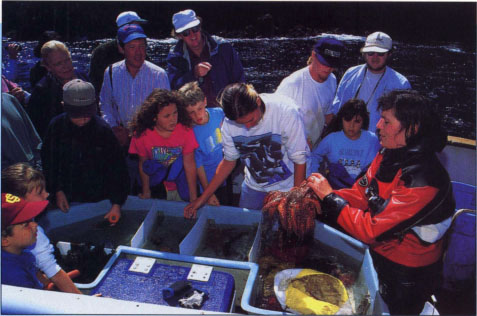
Tourists examine starfish, sea cucumbers and other marine organisms in the “touch tank,” an aquarium aboard the commercial tour boat Condor, and ask questions about marine protected areas.
We have recently released the centralized MPA database, including site characterizations and GIS maps, in a Sea Grant publication, California Marine Protected Areas. The publication was funded by the David and Lucile Packard Foundation and the California Sea Grant College System. We anticipate that our project will assist resource users in following and understanding the often conflicting and confusing regulations for each MPA. In addition, we hope that the publication will help managers and researchers to better understand the system as it presently exists and to begin to develop one that is more integrated.
Further reading
Dugan JE, Davis GE. Applications of marine refugia to coastal fisheries management. Can J Fisheries Aquat Sci. 1992. 50:2029-42.
McArdle DA. California Marine Protected Areas. 1997. California Sea Grant College Publication ISBN 1-888-691-03-4; 268 p.
Polunin NVC. Marine regulated areas: An expanded approach for the tropics. Resource Man Optimiz. 1990. 7:283-99.
Rowley RJ. Case studies and reviews: Marine reserves in fisheries management. Aquat Conserv. Marine Freshwater Ecosys. 1994. 4:233-54. doi:10.1002/aqc.3270040305 https://doi.org/doi:10.1002/aqc.3270040305
Shackell N, Willison JHM. Marine Protected Areas and sustainable fisheries. Science, Management of Marine Protected Areas Association, Nova Scotia 1995.
Smith EJ Jr, Johnson TH. The marine life refuges and reserves of California. California Department of Fish and Game Marine Resources Information Bulletin No. 1 1989. 63.
Marine Protected Areas should be managed with greater integration

